Difference between revisions of "2014-06-30 44 -71"
imported>Mcbaneg (Created page with "<!-- If you did not specify these parameters in the template, please substitute appropriate values for IMAGE, LAT, LON, and DATE (YYYY-MM-DD format) {{{image|dummy.jpg}}}|...") |
m |
||
| (4 intermediate revisions by 2 users not shown) | |||
| Line 8: | Line 8: | ||
And DON'T FORGET to add your expedition and the best photo you took to the gallery on the Main Page! We'd love to read your report, but that means we first have to discover it! :) | And DON'T FORGET to add your expedition and the best photo you took to the gallery on the Main Page! We'd love to read your report, but that means we first have to discover it! :) | ||
--> | --> | ||
| − | [[Image:{{{image|2014-06- | + | [[Image:{{{image|2014-06-30 44 -71 1.jpg}}}|thumb|left]] |
{{meetup graticule | {{meetup graticule | ||
| Line 36: | Line 36: | ||
turns out it's quite hard to cross the Androscoggin River in Gorham, | turns out it's quite hard to cross the Androscoggin River in Gorham, | ||
and requires a 3-mile detour to the east to reach a bridge. Hogan Rd | and requires a 3-mile detour to the east to reach a bridge. Hogan Rd | ||
| − | then goes | + | then goes west from the bridge. After about 20 minutes of 10 mph |
driving along this passable but quite rough forest road, we had come | driving along this passable but quite rough forest road, we had come | ||
within 1.2 km of the hashpoint. At that point we encountered a | within 1.2 km of the hashpoint. At that point we encountered a | ||
Private Road sign and a big homebuilt barrier across the road. The | Private Road sign and a big homebuilt barrier across the road. The | ||
| − | rest of the family | + | rest of the family offered to wait while G. walked to the hashpoint |
and back, but with a 2-hour trip home still ahead and dusk closing in, | and back, but with a 2-hour trip home still ahead and dusk closing in, | ||
we took the No Trespassing photo and headed home. | we took the No Trespassing photo and headed home. | ||
| Line 73: | Line 73: | ||
[[Category:Expeditions with photos]] | [[Category:Expeditions with photos]] | ||
[[Category:Coordinates not reached]] | [[Category:Coordinates not reached]] | ||
| + | [[Category:Not reached - No public access]] | ||
| + | {{location|US|NH|CO}} | ||
Latest revision as of 10:29, 16 March 2022
| Mon 30 Jun 2014 in 44,-71: 44.4012646, -71.1721812 geohashing.info google osm bing/os kml crox |
Location
On Hogan Rd north of Gorham, New Hampshire, USA
Participants
Expedition
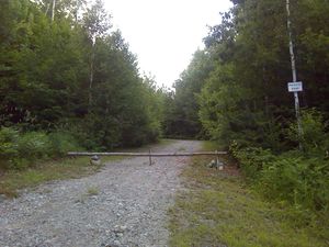
Having completed a family trip with younger cousins to a spot about 20 miles south of this hashpoint, G. convinced the rest of the family to take this longer route home after supper to pick up a hashpoint in another virgin graticule which lay right at the edge of a road. We left the pub about 7 pm, and reached Gorham just before 7:30. It turns out it's quite hard to cross the Androscoggin River in Gorham, and requires a 3-mile detour to the east to reach a bridge. Hogan Rd then goes west from the bridge. After about 20 minutes of 10 mph driving along this passable but quite rough forest road, we had come within 1.2 km of the hashpoint. At that point we encountered a Private Road sign and a big homebuilt barrier across the road. The rest of the family offered to wait while G. walked to the hashpoint and back, but with a 2-hour trip home still ahead and dusk closing in, we took the No Trespassing photo and headed home.
Achievements
George, Susanne, Katja, and Rebekah earned the No trespassing consolation prize
|

