Difference between revisions of "2014-06-29 50 12"
imported>Danatar (short report) |
imported>FippeBot m (Location) |
||
| (One intermediate revision by one other user not shown) | |||
| Line 29: | Line 29: | ||
===tracklog=== | ===tracklog=== | ||
| − | + | [http://www.everytrail.com/view_trip.php?trip_id=2879283&code=8d5774be672c96a82a70503c1627a2a1 Triton tracklog] | |
[[Category:Expeditions]] | [[Category:Expeditions]] | ||
| Line 36: | Line 36: | ||
[[Category:Not reached - No public access]] | [[Category:Not reached - No public access]] | ||
[[Category:Danatar]] | [[Category:Danatar]] | ||
| + | {{location|DE|SN|V}} | ||
Latest revision as of 00:24, 7 August 2019
| Sun 29 Jun 2014 in Chemnitz: 50.5809010, 12.3498212 geohashing.info google osm bing/os kml crox |
Location
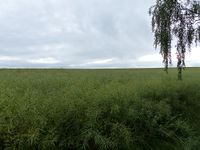
Today's location is in a rapeseed field next to Schönbrunn, near Reichenbach im Vogtland.
Country: Germany; state: Sachsen (Saxony, EU:DE:SN); district: Vogtlandkreis.
Expedition
Danatar
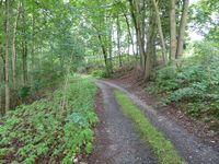
On my way from Würzburg to Dresden, again with my car full of stuff that needs to go to my new appartment, this hashpoint was very near to the Autobahn. I left the A72 at the Reichenbach exit, then drove through Schönbrunn, stopping the car on a small track that branched off of the main road in a small wooded area which covered an incline. I climbed that incline and reached the hashfield, with a track alongside it that just a little further met with the track I had been on before. The field was a rapeseed field and it was quite large. After walking a short bit along its side I realized that I would have to walk about 150 m through the field to get to the spot and instead decided to turn back.
|


