Difference between revisions of "2015-01-26 49 8"
imported>DODO (→Participants) |
imported>FippeBot m (Location) |
||
| (5 intermediate revisions by one other user not shown) | |||
| Line 28: | Line 28: | ||
== Plans == | == Plans == | ||
<!-- what were the original plans --> | <!-- what were the original plans --> | ||
| + | Todays hashpoint is very close to my usual way to the office, so I had to look for it. | ||
== Expedition == | == Expedition == | ||
<!-- how it all turned out. your narrative goes here. --> | <!-- how it all turned out. your narrative goes here. --> | ||
| + | Unfortunately it was raining this morning and so I decided to drive to work by car and not by bull. And so I didn't come along the hashpoint this morning. But on my way home I've choosen to take the shorter route (but not the faster one) and have a stop at the hashpoint. Rain did change into rain and snow in the meantime and so it doesn't look like a convenient way. Nevertheless I parked the car beyond the nearby bridge and started to walk. I walked along a little stream after a while a ditch crossed my way, but I could easily jump over it. After 400m walk I reached the meadow, but it was fenced. As you can see on the pictures, the fence could be crossed easily, but given the ugly weather and the view fom the nearby farmhouses I decided not to do so and walked back. | ||
| + | |||
| + | I guess its a mixture between No trespassing and chicken out, but to progress the posted achievement I decide for the former :-) | ||
== Tracklog == | == Tracklog == | ||
<!-- if your GPS device keeps a log, you may post a link here --> | <!-- if your GPS device keeps a log, you may post a link here --> | ||
| + | [http://www.gpsies.com/map.do?fileId=ljglcjcfjanudwtg 21 KM by car, 1KM by foot], the little peak near the motorway bridge is the walk | ||
== Photos == | == Photos == | ||
| Line 40: | Line 45: | ||
--> | --> | ||
<gallery perrow="5"> | <gallery perrow="5"> | ||
| + | Image:2015-01-26_49_8-1.jpg |The hashpoint seen from the car. Its on the green meadow behind the polished field | ||
| + | Image:2015-01-26_49_8-2.jpg |OK, I could have crossed this fence | ||
| + | Image:2015-01-26_49_8-3.jpg |The colony Siegelhain | ||
| + | Image:2015-01-26_49_8-4.jpg |I had to jump over this ditch twice | ||
| + | Image:2015-01-26_49_8-5.jpg |Water next to the motorway | ||
</gallery> | </gallery> | ||
| Line 45: | Line 55: | ||
{{#vardefine:ribbonwidth|800px}} | {{#vardefine:ribbonwidth|800px}} | ||
<!-- Add any achievement ribbons you earned below, or remove this section --> | <!-- Add any achievement ribbons you earned below, or remove this section --> | ||
| + | {{No trespassing | ||
| + | | latitude = 49 | ||
| + | | longitude = 8 | ||
| + | | date = 2015-01-26 | ||
| + | | name = DODO | ||
| + | | distance = 140m | ||
| + | }} | ||
| − | |||
| − | |||
| − | |||
| − | |||
| − | |||
| − | |||
| − | |||
| − | |||
| − | |||
| − | |||
| − | |||
[[Category:Expeditions]] | [[Category:Expeditions]] | ||
| − | |||
[[Category:Expeditions with photos]] | [[Category:Expeditions with photos]] | ||
| − | |||
| − | |||
| − | |||
| − | |||
| − | |||
| − | |||
| − | |||
| − | |||
| − | |||
[[Category:Coordinates not reached]] | [[Category:Coordinates not reached]] | ||
| − | |||
| − | |||
| − | |||
| − | |||
| − | |||
[[Category:Not reached - No public access]] | [[Category:Not reached - No public access]] | ||
| − | + | {{location|DE|BW|HD}} | |
| − | |||
| − | |||
| − | |||
| − | |||
| − | |||
| − | |||
| − | |||
Latest revision as of 02:33, 15 August 2019
| Mon 26 Jan 2015 in 49,8: 49.3370056, 8.4757438 geohashing.info google osm bing/os kml crox |
Location
A meadow near Siegelhain.
Participants
Plans
Todays hashpoint is very close to my usual way to the office, so I had to look for it.
Expedition
Unfortunately it was raining this morning and so I decided to drive to work by car and not by bull. And so I didn't come along the hashpoint this morning. But on my way home I've choosen to take the shorter route (but not the faster one) and have a stop at the hashpoint. Rain did change into rain and snow in the meantime and so it doesn't look like a convenient way. Nevertheless I parked the car beyond the nearby bridge and started to walk. I walked along a little stream after a while a ditch crossed my way, but I could easily jump over it. After 400m walk I reached the meadow, but it was fenced. As you can see on the pictures, the fence could be crossed easily, but given the ugly weather and the view fom the nearby farmhouses I decided not to do so and walked back.
I guess its a mixture between No trespassing and chicken out, but to progress the posted achievement I decide for the former :-)
Tracklog
21 KM by car, 1KM by foot, the little peak near the motorway bridge is the walk
Photos
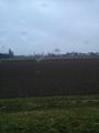
The hashpoint seen from the car. Its on the green meadow behind the polished field
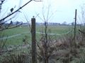
OK, I could have crossed this fence
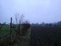
The colony Siegelhain
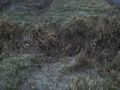
I had to jump over this ditch twice
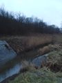
Water next to the motorway


Achievements
DODO earned the No trespassing consolation prize
|