Difference between revisions of "2016-11-04 49 8"
From Geohashing
imported>Q-Owl (Created page with "{{meetup graticule | lat=49 | lon=8 | date=2016-11-04 }}__NOTOC__ == Location == On a field near Wolfskehlen == Participants == *Q-Owl *User:Q-Owla|Q-Ow...") |
imported>FippeBot m (Location) |
||
| (3 intermediate revisions by one other user not shown) | |||
| Line 1: | Line 1: | ||
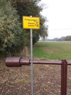
| + | [[Image:2016-11-04 49 8 nt.jpg|thumb|left|No trespassing]] | ||
{{meetup graticule | {{meetup graticule | ||
| lat=49 | | lat=49 | ||
| Line 19: | Line 20: | ||
== Expedition == | == Expedition == | ||
| − | No | + | We walked about 700 m to the hash point and got wet shoes, but there was a nice yellow No trespassing sign. Only 70 m distance between us and the hp. :-( |
| − | |||
| − | |||
| − | + | But we found a few geocaches and three [https://safari.flopp.net/ safari caches]. :-)) | |
| − | |||
== Photos == | == Photos == | ||
<gallery perrow="5" > | <gallery perrow="5" > | ||
| − | Image:2016-11-04 49 8 proof.png | | + | Image:2016-11-04 49 8 proof.png | 70 m off :-( |
Image:2016-11-04 49 8 nt.jpg | No trespassing | Image:2016-11-04 49 8 nt.jpg | No trespassing | ||
| + | Image:2016-11-04 49 8 of.jpg | HP on the field | ||
Image:2016-11-04 49 8 ng.jpg | No grin | Image:2016-11-04 49 8 ng.jpg | No grin | ||
| − | |||
</gallery> | </gallery> | ||
<!-- | <!-- | ||
| Line 89: | Line 87: | ||
[[Category: Meetup on 2016-11-04]] | [[Category: Meetup on 2016-11-04]] | ||
[[Category: Meetup in 49 8]] | [[Category: Meetup in 49 8]] | ||
| + | {{location|DE|HE|GG}} | ||
Latest revision as of 01:43, 16 August 2019
| Fri 4 Nov 2016 in 49,8: 49.8641879, 8.5074497 geohashing.info google osm bing/os kml crox |
Location
On a field near Wolfskehlen
Participants
Plan
Drive near the hashpoint, walk to it (if possible), take fotos and find a few geocaches.
On the satellite fotos seemed to be a chance to reach the hash point on a meadow or a field.
Expedition
We walked about 700 m to the hash point and got wet shoes, but there was a nice yellow No trespassing sign. Only 70 m distance between us and the hp. :-(
But we found a few geocaches and three safari caches. :-))
Photos
Achievements / Honorable Mention
Q-Owl earned the Land geohash achievement
|
Q-Owl earned the No trespassing consolation prize
|
Other Geohashing Expeditions and Plans on this Day
Expeditions and Plans
| 2016-11-04 | ||
|---|---|---|
| Salt Lake City, Utah | Eldin | In a wetland between Bountiful an the Great Salt Lake |
| Buffalo, New York | Pedalpusher | Fort Erie, Canada in an empty lot near the Fort Erie Chamber of Commerce |
| Mannheim, Germany | Q-Owl, Q-Owla | On a field near Wolfskehlen |
| Nilsiä, Finland | Pastori, The Wife | Rumo, Valtimo, Finland. The point lies on the bank of a forest road. |


