Difference between revisions of "2016-11-13 54 -2"
From Geohashing
imported>Angel (An expedition message sent via Geohash Droid for Android.) |
m |
||
| (5 intermediate revisions by 4 users not shown) | |||
| Line 24: | Line 24: | ||
<!-- who attended: If you link to your wiki user name in this section, your expedition will be picked up by the various statistics generated for geohashing. You may use three tildes ~ as a shortcut to automatically insert the user signature of the account you are editing with. | <!-- who attended: If you link to your wiki user name in this section, your expedition will be picked up by the various statistics generated for geohashing. You may use three tildes ~ as a shortcut to automatically insert the user signature of the account you are editing with. | ||
--> | --> | ||
| + | *[[User:Angel|Angel]] | ||
== Plans == | == Plans == | ||
| Line 39: | Line 40: | ||
--> | --> | ||
<gallery perrow="5"> | <gallery perrow="5"> | ||
| + | |||
| + | Image:2016-11-13_54_-2_Angel_1479209848384.jpg|Not really a success. Hash was within the GPS error circle; and our actualposition was closer to the hash than to the dot on the map. But I don't think I can claim it with accuracy this low. We were on the train, so couldn't approach the last 200m-ish. | ||
</gallery> | </gallery> | ||
| Line 45: | Line 48: | ||
<!-- Add any achievement ribbons you earned below, or remove this section --> | <!-- Add any achievement ribbons you earned below, or remove this section --> | ||
| − | |||
| − | |||
| − | |||
| − | |||
| − | |||
| − | |||
| − | |||
| − | |||
| − | |||
| − | |||
| − | |||
| − | |||
| − | |||
| − | |||
[[Category:Expeditions]] | [[Category:Expeditions]] | ||
| − | |||
| − | |||
| − | |||
| − | |||
| − | |||
| − | |||
| − | |||
| − | |||
| − | |||
| − | |||
| − | |||
[[Category:Coordinates not reached]] | [[Category:Coordinates not reached]] | ||
| − | + | [[Category:Not reached - Time constraints]] | |
| − | + | {{location|GB|ENG|CMA}} | |
| − | |||
| − | |||
| − | |||
| − | [[Category:Not reached - | ||
| − | |||
| − | |||
| − | |||
| − | |||
| − | |||
| − | |||
| − | |||
| − | |||
Latest revision as of 11:20, 27 March 2022
| Sun 13 Nov 2016 in 54,-2: 54.8109590, -2.8513097 geohashing.info google osm bing/os kml crox |
Location
Participants
Plans
Expedition
Tracklog
Photos
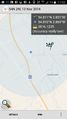
Not really a success. Hash was within the GPS error circle; and our actualposition was closer to the hash than to the dot on the map. But I don't think I can claim it with accuracy this low. We were on the train, so couldn't approach the last 200m-ish.
