Difference between revisions of "2017-01-10 -35 149"
imported>1PE (Created page with "{{subst:Expedition |lat = -35 |lon = 149 |date = 2017-01-10}}") |
imported>FippeBot m (Location) |
||
| (4 intermediate revisions by 2 users not shown) | |||
| Line 19: | Line 19: | ||
== Location == | == Location == | ||
| − | + | In a bend of the Molonglo River within the Molonglo Gorge Recreation Area, north-west of the industrial estate in the city of Queanbeyan. The hash is by definition inside the Australian Capital Territory. | |
== Participants == | == Participants == | ||
| + | * [[User:1PE|1PE]] | ||
<!-- who attended: If you link to your wiki user name in this section, your expedition will be picked up by the various statistics generated for geohashing. You may use three tildes ~ as a shortcut to automatically insert the user signature of the account you are editing with. | <!-- who attended: If you link to your wiki user name in this section, your expedition will be picked up by the various statistics generated for geohashing. You may use three tildes ~ as a shortcut to automatically insert the user signature of the account you are editing with. | ||
--> | --> | ||
== Plans == | == Plans == | ||
| − | + | ===[[User:1PE|1PE]]=== | |
| + | Go to the industrial estate and see whether there was a view across to where the hash site was situated; there was no practical way to get to the hash. | ||
== Expedition == | == Expedition == | ||
| − | + | ===[[User:1PE|1PE]]=== | |
| + | I went to the industrial estate that backs onto the railway line that marks the boundary between the state of New South Wales (NSW) and the Australian Capital Territory (ACT). The estate is within NSW, and is bordered along its western and northern sides by the railway line that marks the NSW/ACT border at that place. The hash is on a peninsular formed by a loop of the Molonglo River where it cuts a gorge into the landscape as it comes past the city of Queanbeyan. | ||
| + | |||
| + | The nearest point to the hash was a woodyard. Its western border has trees along the railway line, and I could not see through them to the hash. I took a picture, anyway, along the wall-line of a saw shed that 'points' to the hash. | ||
| + | |||
| + | On the road back, I got near the railway line easement and realised that I could see the peninsular of the hash. So, I took a picture showing me and the hash beyond. | ||
| + | |||
| + | Picture to follow :-) | ||
== Tracklog == | == Tracklog == | ||
| Line 39: | Line 48: | ||
--> | --> | ||
<gallery perrow="5"> | <gallery perrow="5"> | ||
| + | Image:2017-01-10_-35_149_161827.jpg|The wood yard, stopping us see the hash point beyond. | ||
| + | Image:2017-01-10_-35_149_162046.jpg|Railway, and the peninsular beyond. | ||
| + | Image:2017-01-10_-35_149_162304.jpg|Hash to the right of my glasses. | ||
</gallery> | </gallery> | ||
| Line 46: | Line 58: | ||
<!-- =============== USEFUL CATEGORIES FOLLOW ================ | <!-- =============== USEFUL CATEGORIES FOLLOW ================ | ||
| − | + | ||
| − | + | ||
<!-- ==REQUEST FOR TWITTER BOT== Please leave either the New report or the Expedition planning category in as long as you work on it. This helps the twitter bot a lot with announcing the right outcome at the right moment. --> | <!-- ==REQUEST FOR TWITTER BOT== Please leave either the New report or the Expedition planning category in as long as you work on it. This helps the twitter bot a lot with announcing the right outcome at the right moment. --> | ||
| Line 58: | Line 70: | ||
<!-- If all those plans are never acted upon, change [[Category:Expedition planning]] to [[Category:Not reached - Did not attempt]]. --> | <!-- If all those plans are never acted upon, change [[Category:Expedition planning]] to [[Category:Not reached - Did not attempt]]. --> | ||
| + | [[Category:Expeditions]] | ||
<!-- An actual expedition: | <!-- An actual expedition: | ||
| − | + | ||
-- and one or more of -- | -- and one or more of -- | ||
| − | + | ||
[[Category:Expeditions with videos]] | [[Category:Expeditions with videos]] | ||
[[Category:Expedition without GPS]] | [[Category:Expedition without GPS]] | ||
--> | --> | ||
| − | + | [[Category:Expeditions with photos]] | |
<!-- if you reached your coords: | <!-- if you reached your coords: | ||
[[Category:Coordinates reached]] | [[Category:Coordinates reached]] | ||
| − | --> | + | --> |
[[Category:Coordinates not reached]] | [[Category:Coordinates not reached]] | ||
| + | [[Category:Not reached - No public access]] | ||
| + | |||
| + | <!-- or if you failed :( | ||
| + | |||
-- and a reason -- | -- and a reason -- | ||
When there is a natural obstacle between you and the target: | When there is a natural obstacle between you and the target: | ||
| Line 77: | Line 94: | ||
When there is a man-made obstacle between you and the target: | When there is a man-made obstacle between you and the target: | ||
| − | + | ||
When you failed get your GPS, car, bike or such to work: | When you failed get your GPS, car, bike or such to work: | ||
| Line 86: | Line 103: | ||
(Don't forget to delete this final close comment marker) --> | (Don't forget to delete this final close comment marker) --> | ||
| + | {{location|AU|ACT}} | ||
Latest revision as of 18:19, 26 July 2019
| Tue 10 Jan 2017 in -35,149: -35.3296923, 149.2465543 geohashing.info google osm bing/os kml crox |
Location
In a bend of the Molonglo River within the Molonglo Gorge Recreation Area, north-west of the industrial estate in the city of Queanbeyan. The hash is by definition inside the Australian Capital Territory.
Participants
Plans
1PE
Go to the industrial estate and see whether there was a view across to where the hash site was situated; there was no practical way to get to the hash.
Expedition
1PE
I went to the industrial estate that backs onto the railway line that marks the boundary between the state of New South Wales (NSW) and the Australian Capital Territory (ACT). The estate is within NSW, and is bordered along its western and northern sides by the railway line that marks the NSW/ACT border at that place. The hash is on a peninsular formed by a loop of the Molonglo River where it cuts a gorge into the landscape as it comes past the city of Queanbeyan.
The nearest point to the hash was a woodyard. Its western border has trees along the railway line, and I could not see through them to the hash. I took a picture, anyway, along the wall-line of a saw shed that 'points' to the hash.
On the road back, I got near the railway line easement and realised that I could see the peninsular of the hash. So, I took a picture showing me and the hash beyond.
Picture to follow :-)
Tracklog
Photos
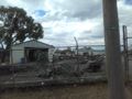
The wood yard, stopping us see the hash point beyond.
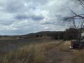
Railway, and the peninsular beyond.
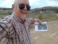
Hash to the right of my glasses.


