Difference between revisions of "2018-05-15 51 6"
imported>Pah (Starting report) |
imported>FippeBot m (Location) |
||
| (2 intermediate revisions by one other user not shown) | |||
| Line 1: | Line 1: | ||
| − | + | [[Image:{{{image|2018-05-15_51_6_pah_002.jpg}}}|thumb|right]] | |
| − | |||
| − | |||
| − | [[Image:{{{image| | ||
| − | |||
| − | |||
| − | |||
| − | |||
| − | |||
| − | |||
{{meetup graticule | {{meetup graticule | ||
| lat=51 | | lat=51 | ||
| Line 15: | Line 6: | ||
}} | }} | ||
| − | |||
__NOTOC__ | __NOTOC__ | ||
== Location == | == Location == | ||
| − | + | ||
| + | At/in the [[wikipedia::Rhine|Rhine]] river close to [[wikipedia:Düsseldorf|Düsseldorf]]-Flehe, located in a restricted area. | ||
| + | |||
== Participants == | == Participants == | ||
| − | + | * [[User:Pah|pah]] [[File:U+110DB.png|middle|6px|link=User:Pah]] ([[2016-12-10 51 6|prev]]|[[2018-05-19 51 6|next]]) | |
| − | -- | ||
| − | == | + | == Expedition == |
| − | |||
| − | + | After a long pause without any expeditions for more than a year, I noticed that today's hash was relatively close to my home and wanted to give it a shot again. It already looked quite challenging, as the geohash looked to be placed inside the [[wikipedia:Rhine|Rhine]] river. But as it was reasonably close to the shore, I still tried -- there could be low water in the river after all. So I took the tram and walked to the river, where the final trip began. I arrived at around 20:30 and the weather was pleasant to have a nice evening walk. | |
| − | |||
| − | + | After passing below the "Fleher Brücke" ([[wikipedia:Bundesautobahn_46|A46]]), my walk was unpleasantly stopped by a high fence and a "no trespassing" sign: The geohash was located in a water protection area ([https://de.wikipedia.org/wiki/Wasserschutzgebiet Wasserschutzgebiet]). At that point, I was about 300m away from the hash and could already see it! I then tried following the fence, looking for a way to get closer. After a while, I reached another gate, blocking the entrance via a path inside the area - still 230m away. So I further strolled along the fence on a small road through the forest. My closest distance to the hash was 154m, where a small bench was conveniently placed on the side of the road. So I took a break, frowned towards the hash and continued my evening walk through the forest for a while, enjoying the nice warm evening. | |
| − | |||
== Photos == | == Photos == | ||
| − | < | + | |
| − | Image: | + | <gallery perrow="4"> |
| − | -- | + | Image:2018-05-15 51 6 pah 000.png | Starting point |
| − | + | Image:2018-05-15 51 6 pah 001.jpg | View towards the hash | |
| + | Image:2018-05-15 51 6 pah 002.jpg | Disappointing fence | ||
| + | Image:2018-05-15 51 6 pah 003.png | Crossroads | ||
| + | Image:2018-05-15 51 6 pah 004.jpg | Still fence, closed gate | ||
| + | Image:2018-05-15 51 6 pah 005.png | As close as I got | ||
| + | Image:2018-05-15 51 6 pah 006.jpg | Feet pointing towards the hash | ||
| + | Image:2018-05-15 51 6 pah 007.jpg | Stupid frown™ | ||
</gallery> | </gallery> | ||
== Achievements == | == Achievements == | ||
{{#vardefine:ribbonwidth|800px}} | {{#vardefine:ribbonwidth|800px}} | ||
| − | + | {{No trespassing | |
| − | |||
| − | |||
| − | |||
| − | |||
| − | |||
| − | |||
| − | + | | latitude = 51 | |
| − | + | | longitude = 6 | |
| − | [[ | + | | date = 2018-05-15 |
| − | -- | + | | name = [[User:Pah|pah]] [[File:U+110DB.png|middle|6px|link=User:Pah]] |
| + | | image = 2018-05-15 51 6 pah 004.jpg | ||
| + | | distance = 154.73 m | ||
| − | + | }} | |
| − | |||
[[Category:Expeditions]] | [[Category:Expeditions]] | ||
| − | |||
[[Category:Expeditions with photos]] | [[Category:Expeditions with photos]] | ||
| − | |||
| − | |||
| − | |||
| − | |||
| − | |||
| − | |||
| − | |||
| − | |||
| − | |||
[[Category:Coordinates not reached]] | [[Category:Coordinates not reached]] | ||
| − | |||
| − | |||
| − | |||
| − | |||
| − | |||
[[Category:Not reached - No public access]] | [[Category:Not reached - No public access]] | ||
| − | + | {{location|DE|NW|D}} | |
| − | |||
| − | |||
| − | |||
| − | |||
| − | |||
| − | |||
| − | |||
Latest revision as of 03:37, 16 August 2019

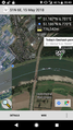
| Tue 15 May 2018 in 51,6: 51.1869396, 6.7805520 geohashing.info google osm bing/os kml crox |
Location
At/in the Rhine river close to Düsseldorf-Flehe, located in a restricted area.
Participants
Expedition
After a long pause without any expeditions for more than a year, I noticed that today's hash was relatively close to my home and wanted to give it a shot again. It already looked quite challenging, as the geohash looked to be placed inside the Rhine river. But as it was reasonably close to the shore, I still tried -- there could be low water in the river after all. So I took the tram and walked to the river, where the final trip began. I arrived at around 20:30 and the weather was pleasant to have a nice evening walk.
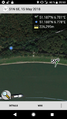
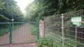
After passing below the "Fleher Brücke" (A46), my walk was unpleasantly stopped by a high fence and a "no trespassing" sign: The geohash was located in a water protection area (Wasserschutzgebiet). At that point, I was about 300m away from the hash and could already see it! I then tried following the fence, looking for a way to get closer. After a while, I reached another gate, blocking the entrance via a path inside the area - still 230m away. So I further strolled along the fence on a small road through the forest. My closest distance to the hash was 154m, where a small bench was conveniently placed on the side of the road. So I took a break, frowned towards the hash and continued my evening walk through the forest for a while, enjoying the nice warm evening.
Photos
Starting point
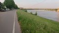
View towards the hash
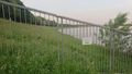
Disappointing fence
Crossroads
Still fence, closed gate
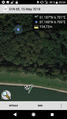
As close as I got
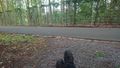
Feet pointing towards the hash

Stupid frown™


Achievements
pah
|