Difference between revisions of "2018-06-16 51 0"
imported>Saxbophone (Create expedition page) |
imported>FippeBot m (Location) |
||
| (14 intermediate revisions by 2 users not shown) | |||
| Line 22: | Line 22: | ||
== Expedition == | == Expedition == | ||
| − | '''[ | + | [[User:Saxbophone|Saxbophone]] ([[User talk:Saxbophone|talk]]) and Robert arrived at London Bridge station by Tube and (after a quick stock-up on snacks) caught the 14:07 train to Uckfield. Our train arrived at Edenbridge Town station at 14:43 (''2 minutes early, Southern Railway sure are reclaiming their reputation![https://www.getsurrey.co.uk/news/surrey-news/southern-rail-boss-resigns-following-14789265]''). |
| + | |||
| + | We then proceeded through the town of Edenbridge, heading south down the high street then turning west by the Waitrose to head to the riverside footpaths. I started using my new GPS to navigate once we were out of the train station (''GPS is a marvellous thing isn't it?''). | ||
| + | |||
| + | After a brief hesitation, we decided to take the northerly path that goes away from the river Eden rather than the one that follows it. We took a fairly meandering, diagonal route through many fields with long grass. This public footpath we followed sure does traverse its fair share of fields! | ||
| + | |||
| + | We had to double-back on ourselves a bit to negotiate the river Eden, which was in our way a bit. A few times we had to go back on ourselves after realising we were going the wrong way (which is reflected in the included tracklog). | ||
| + | |||
| + | At just under 200 metres from the location, we encountered the most interesting feature we encountered on our expedition today, an Airfield! Strange as it seemed, the public footpath clearly crossed the runways of this airfield (with notable yellow signs at both entrances warning walkers to be wary of aircraft). Crossing an active runway was one of the freakiest things I've ever done, but we applied the ''Green Cross Code''[https://en.wikipedia.org/wiki/Green_Cross_Code] in this situation and this worked well for us (except if I saw a plane coming I wouldn't ''stop'', I'd run the hell away!). There were no signs that we could see identifying the airfield, but based on its location I think it is called '''East Haxted Farm Airfield'''[http://www.ukairfieldguide.net/airfields/East-Haxted-Farm]. | ||
| + | |||
| + | We also saw two Pill Boxes[https://en.wikipedia.org/wiki/British_hardened_field_defences_of_World_War_II] around this area —perhaps the airfield we traversed was a former RAF site? | ||
| + | |||
| + | On the journey, we had to cross a few bridges over the river Eden and other streams that interact with it. | ||
| + | |||
| + | The final landmarks we passed before getting the closest we could to the location were a camping ground and a fishery. | ||
| + | |||
| + | In the end, we were able to get within 131 metres of the location, a kink in the track running parallel to the river Eden on the south side of it. We could see where the location was, a yellow field just on the other side of a private woodland area. We assumed that the field in which the location was situated was also private, so decided to call it a day. | ||
| + | |||
| + | Despite not actually reaching the location, we were rather pleased to have got as close as we did, particularly given the distance we travelled from home. | ||
| + | |||
| + | Also, congrats to Robert whose first Geohashing adventure this was! Do I qualify for the ''dragging'' achievement even if the person I 'dragged' and I didn't get all the way to the location? | ||
| + | |||
| + | Robert just wanted to remark that '''''"A fun time was had by all, the grass was green!"'''''. | ||
| + | |||
| + | == Tracklog == | ||
| + | |||
| + | [[Image:2018-06-16_51_0_Saxbophone_tracklog.png|600px]] | ||
== Photos == | == Photos == | ||
| + | Thanks to my friend Robert for taking these pictures with his smartphone, a thing which I deliberately do not have. --[[User:Saxbophone|Saxbophone]] ([[User talk:Saxbophone|talk]]) | ||
<!-- Insert pictures between the gallery tags using the following format: | <!-- Insert pictures between the gallery tags using the following format: | ||
Image:2012-##-## ## ## Alpha.jpg | Witty Comment | Image:2012-##-## ## ## Alpha.jpg | Witty Comment | ||
--> | --> | ||
<gallery> | <gallery> | ||
| + | Image:2018-06-16_51_0_Saxbophone_135935.jpg | About to board the train at London Bridge station! | ||
| + | Image:2018-06-16_51_0_Saxbophone_150111.jpg | Some information about the Edenbridge bridge over the river Eden | ||
| + | Image:2018-06-16_51_0_Saxbophone_152314.jpg | The runway of this airfield is just visible behind me (it's the flat smooth patch of grass) | ||
| + | Image:2018-06-16_51_0_Saxbophone_155456.jpg | Footpath crosses the airstrip? | ||
| + | Image:2018-06-16_51_0_Saxbophone_155458.jpg | No problem! | ||
| + | Image:2018-06-16_51_0_Saxbophone_160601.jpg | We were so close! (131m) | ||
| + | Image:2018-06-16_51_0_Saxbophone_161427.jpg | Saxbophone gleeful about getting as close to the location as he did | ||
| + | Image:2018-06-16_51_0_Saxbophone_160822.jpg | Another reading from the GPS we used (along with some form of indication of roughly what time it was) | ||
</gallery> | </gallery> | ||
| Line 34: | Line 69: | ||
{{#vardefine:ribbonwidth|800px}} | {{#vardefine:ribbonwidth|800px}} | ||
<!-- Add any achievement ribbons you earned below, or remove this section --> | <!-- Add any achievement ribbons you earned below, or remove this section --> | ||
| + | {{No trespassing | latitude = 51 | longitude = 0 | date = 2018-06-16 | name = Saxbophone | distance = 131m }} | ||
| − | |||
| − | |||
| − | |||
| − | |||
| − | |||
| − | |||
| − | |||
| − | |||
| − | |||
| − | |||
| − | |||
| − | |||
| − | |||
[[Category:Expeditions]] | [[Category:Expeditions]] | ||
| − | |||
[[Category:Expeditions with photos]] | [[Category:Expeditions with photos]] | ||
| − | |||
| − | |||
| − | |||
| − | |||
| − | |||
| − | |||
| − | |||
| − | |||
| − | |||
[[Category:Coordinates not reached]] | [[Category:Coordinates not reached]] | ||
| − | |||
| − | |||
| − | |||
| − | |||
| − | |||
[[Category:Not reached - No public access]] | [[Category:Not reached - No public access]] | ||
| − | + | [[Category:Beard]] | |
| − | + | {{location|GB|ENG|KEN}} | |
| − | [[Category: | ||
| − | |||
| − | |||
| − | |||
| − | |||
| − | |||
Latest revision as of 03:43, 16 August 2019
| Sat 16 Jun 2018 in London East: 51.1846292, 0.0526949 geohashing.info google osm bing/os kml crox |
Location
51.18462921, 0.05269490, in the middle of a field south of the river Eden, in the south-west of Edenbridge, Kent, England, United Kingdom. (near the Kent-Surrey border).
Participants
- Saxbophone (talk)
- Saxbophone's friend Robert
Plans
We plan to set out from London Bridge station and proceed to Edenbridge Town station by train. We will then walk along the public footpaths that follow the river Eden to get as close to the location as legally possible.
Expedition
Saxbophone (talk) and Robert arrived at London Bridge station by Tube and (after a quick stock-up on snacks) caught the 14:07 train to Uckfield. Our train arrived at Edenbridge Town station at 14:43 (2 minutes early, Southern Railway sure are reclaiming their reputation![1]).
We then proceeded through the town of Edenbridge, heading south down the high street then turning west by the Waitrose to head to the riverside footpaths. I started using my new GPS to navigate once we were out of the train station (GPS is a marvellous thing isn't it?).
After a brief hesitation, we decided to take the northerly path that goes away from the river Eden rather than the one that follows it. We took a fairly meandering, diagonal route through many fields with long grass. This public footpath we followed sure does traverse its fair share of fields!
We had to double-back on ourselves a bit to negotiate the river Eden, which was in our way a bit. A few times we had to go back on ourselves after realising we were going the wrong way (which is reflected in the included tracklog).
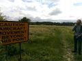
At just under 200 metres from the location, we encountered the most interesting feature we encountered on our expedition today, an Airfield! Strange as it seemed, the public footpath clearly crossed the runways of this airfield (with notable yellow signs at both entrances warning walkers to be wary of aircraft). Crossing an active runway was one of the freakiest things I've ever done, but we applied the Green Cross Code[2] in this situation and this worked well for us (except if I saw a plane coming I wouldn't stop, I'd run the hell away!). There were no signs that we could see identifying the airfield, but based on its location I think it is called East Haxted Farm Airfield[3].
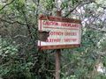
We also saw two Pill Boxes[4] around this area —perhaps the airfield we traversed was a former RAF site?
On the journey, we had to cross a few bridges over the river Eden and other streams that interact with it.
The final landmarks we passed before getting the closest we could to the location were a camping ground and a fishery.
In the end, we were able to get within 131 metres of the location, a kink in the track running parallel to the river Eden on the south side of it. We could see where the location was, a yellow field just on the other side of a private woodland area. We assumed that the field in which the location was situated was also private, so decided to call it a day.
Despite not actually reaching the location, we were rather pleased to have got as close as we did, particularly given the distance we travelled from home.
Also, congrats to Robert whose first Geohashing adventure this was! Do I qualify for the dragging achievement even if the person I 'dragged' and I didn't get all the way to the location?
Robert just wanted to remark that "A fun time was had by all, the grass was green!".
Tracklog

Photos
Thanks to my friend Robert for taking these pictures with his smartphone, a thing which I deliberately do not have. --Saxbophone (talk)
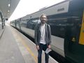
About to board the train at London Bridge station!
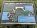
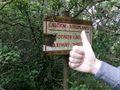
Some information about the Edenbridge bridge over the river Eden
The runway of this airfield is just visible behind me (it's the flat smooth patch of grass)
Footpath crosses the airstrip?
No problem!
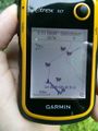
We were so close! (131m)
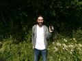
Saxbophone gleeful about getting as close to the location as he did
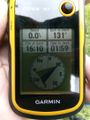
Another reading from the GPS we used (along with some form of indication of roughly what time it was)


Achievements
Saxbophone earned the No trespassing consolation prize
|