Difference between revisions of "2008-06-01 1 103"
imported>R0d3n7z m (add categories) |
imported>FippeBot m (Location) |
||
| (5 intermediate revisions by 3 users not shown) | |||
| Line 17: | Line 17: | ||
'''Doomed to fail''', but I thought it was a good excuse to go for a walk since the weather was quite pleasant (cloudy, not too hot) and went anyway, just to see how close I could get. My local street directory and Google Maps both marked [http://maps.google.com/maps?q=1.35,103.922&t=p&z=15 (1.35,103.922)] as a "quarry park", which I hoped would allow me to reach within 415 meters of the actual coords. Instead, I found a plot of state land, and was only able to get to within about 450 meters of the actual location. | '''Doomed to fail''', but I thought it was a good excuse to go for a walk since the weather was quite pleasant (cloudy, not too hot) and went anyway, just to see how close I could get. My local street directory and Google Maps both marked [http://maps.google.com/maps?q=1.35,103.922&t=p&z=15 (1.35,103.922)] as a "quarry park", which I hoped would allow me to reach within 415 meters of the actual coords. Instead, I found a plot of state land, and was only able to get to within about 450 meters of the actual location. | ||
| − | + | ====Route==== | |
| − | + | [http://maps.google.com/maps/ms?msa=0&msid=108926863438721193959.00044ec48d86c2c3e3091&t=k&z=15&ll=1.345701,103.918433 Expedition route on Google Maps] | |
| − | '''1.''' Alighted from bus, start walking from here. | + | '''[http://maps.google.com/maps/ms?msa=0&msid=108926863438721193959.00044ec48d86c2c3e3091&z=15&iwloc=00044ec4d61d0413cb887 1.]''' Alighted from bus, start walking from here. |
| − | '''2.''' Found a break in the fence, checked it out, found a few people fishing (illegally!). Decided to abide by the law, turned back onto the road. | + | '''[http://maps.google.com/maps/ms?msa=0&msid=108926863438721193959.00044ec48d86c2c3e3091&z=15&iwloc=00044ec4d9ba55f92d46a 2.]''' Found a break in the fence, checked it out, found a few people fishing (illegally!). Decided to abide by the law, turned back onto the road. |
| − | '''3.''' Main entrance to the sand storage area. Took photos: [[:Image:20080601 1 103 1.jpg |1]], [[:Image:20080601 1 103 2.jpg |2]]. | + | '''[http://maps.google.com/maps/ms?msa=0&msid=108926863438721193959.00044ec48d86c2c3e3091&z=15&iwloc=00044ec4e0ef7ed70b9f6 3.]''' Main entrance to the sand storage area. Took photos: [[:Image:20080601 1 103 1.jpg |1]], [[:Image:20080601 1 103 2.jpg |2]]. |
| − | '''4.''' Point of closest approach to the coordinates; time was 17:07. From here, I was able to see vegetation inside the airbase [http://maps.google.com/maps?q=1.3475,103.9148&t=k&z=16 (1.3475,103.9148)]. There was also an opening to a large drain/sewer that appeared to run underneath the sand store and toward the airbase (marked in yellow on expedition map). I didn't go in there because I wasn't equipped to climb back out again. [[:Image:20080601 1 103 3.jpg |Photo]] | + | '''[http://maps.google.com/maps/ms?msa=0&msid=108926863438721193959.00044ec48d86c2c3e3091&z=15&iwloc=00044ec4e0efb4946d2ab 4.]''' Point of closest approach to the coordinates; time was 17:07. From here, I was able to see vegetation inside the airbase [http://maps.google.com/maps?q=1.3475,103.9148&t=k&z=16 (1.3475,103.9148)]. There was also an opening to a large drain/sewer that appeared to run underneath the sand store and toward the airbase (marked in yellow on expedition map). I didn't go in there because I wasn't equipped to climb back out again. [[:Image:20080601 1 103 3.jpg |Photo]] |
| − | '''5.''' Tried to follow the road up the viaduct, but turned back for safety reasons when the sidewalk ended. [[:Image:20080601 1 103 4.jpg |Photo]] shows waterworks. | + | '''[http://maps.google.com/maps/ms?msa=0&msid=108926863438721193959.00044ec48d86c2c3e3091&z=15&iwloc=00044ec4e8725be0fcc01 5.]''' Tried to follow the road up the viaduct, but turned back for safety reasons when the sidewalk ended. [[:Image:20080601 1 103 4.jpg |Photo]] shows waterworks. |
'''6.''' Random [[:Image:20080601 1 103 5.jpg |photo]] of fiber optic perimeter security system on waterworks fence. | '''6.''' Random [[:Image:20080601 1 103 5.jpg |photo]] of fiber optic perimeter security system on waterworks fence. | ||
| Line 35: | Line 35: | ||
'''7.''' [[:Image:20080601 1 103 6.jpg |Photo]] of warning sign posted at waterworks. Similar signs were also found at military driving school and prison school. | '''7.''' [[:Image:20080601 1 103 6.jpg |Photo]] of warning sign posted at waterworks. Similar signs were also found at military driving school and prison school. | ||
| − | '''8.''' Random [[:Image:20080601 1 103 7.jpg |photo]] of the viaduct. | + | '''[http://maps.google.com/maps/ms?msa=0&msid=108926863438721193959.00044ec48d86c2c3e3091&z=15&iwloc=00044ec506b6492fc5521 8.]''' Random [[:Image:20080601 1 103 7.jpg |photo]] of the viaduct. |
No photo of military driving school, not sure if that would have been legal or not. | No photo of military driving school, not sure if that would have been legal or not. | ||
| − | '''9.''' I'd hoped that the construction shown in Google Maps would have been completed, but it was still in progress. Construction site was fenced in, with security. It's a pretty secluded area, so I got strange looks from several (foreign) construction workers (some of whom were near naked and bathing out in the open!). | + | '''[http://maps.google.com/maps/ms?msa=0&msid=108926863438721193959.00044ec48d86c2c3e3091&z=15&iwloc=00044ec50a53537d46240 9.]''' I'd hoped that the construction shown in Google Maps would have been completed, but it was still in progress. Construction site was fenced in, with security. It's a pretty secluded area, so I got strange looks from several (foreign) construction workers (some of whom were near naked and bathing out in the open!). |
| − | + | '''[http://maps.google.com/maps/ms?msa=0&msid=108926863438721193959.00044ec48d86c2c3e3091&z=15&iwloc=00044ec50deeddf053c4b 10.]''' I continued with my nice little stroll for a bit more before taking a bus home. | |
<gallery caption="Pictures" widths="200px" heights="150px" perrow="3"> | <gallery caption="Pictures" widths="200px" heights="150px" perrow="3"> | ||
| Line 55: | Line 55: | ||
[[Category:Expeditions]] | [[Category:Expeditions]] | ||
[[Category:Expeditions with photos]] | [[Category:Expeditions with photos]] | ||
| + | [[Category:Coordinates not reached]] | ||
| + | [[Category:Not reached - No public access]] | ||
| + | [[Category:Expedition without GPS]] | ||
| + | {{location|SG|NE}} | ||
Latest revision as of 04:34, 7 August 2019
| Sun 1 Jun 2008 in 1,103: 1.3491079, 103.9162389 geohashing.info google osm bing/os kml crox |
Contents
About
1.3491079341188037, 103.9162389042702137
Inside Paya Lebar Airbase, along the eastern side perimeter, near Kaki Bukit sand store. Air force personnel may score a Restricted Area Geohash.
Expeditions
r0d3n7z
Doomed to fail, but I thought it was a good excuse to go for a walk since the weather was quite pleasant (cloudy, not too hot) and went anyway, just to see how close I could get. My local street directory and Google Maps both marked (1.35,103.922) as a "quarry park", which I hoped would allow me to reach within 415 meters of the actual coords. Instead, I found a plot of state land, and was only able to get to within about 450 meters of the actual location.
Route
Expedition route on Google Maps
1. Alighted from bus, start walking from here.
2. Found a break in the fence, checked it out, found a few people fishing (illegally!). Decided to abide by the law, turned back onto the road.
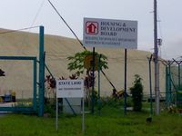
3. Main entrance to the sand storage area. Took photos: 1, 2.
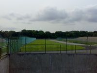
4. Point of closest approach to the coordinates; time was 17:07. From here, I was able to see vegetation inside the airbase (1.3475,103.9148). There was also an opening to a large drain/sewer that appeared to run underneath the sand store and toward the airbase (marked in yellow on expedition map). I didn't go in there because I wasn't equipped to climb back out again. Photo
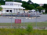
5. Tried to follow the road up the viaduct, but turned back for safety reasons when the sidewalk ended. Photo shows waterworks.
6. Random photo of fiber optic perimeter security system on waterworks fence.
7. Photo of warning sign posted at waterworks. Similar signs were also found at military driving school and prison school.
8. Random photo of the viaduct.
No photo of military driving school, not sure if that would have been legal or not.
9. I'd hoped that the construction shown in Google Maps would have been completed, but it was still in progress. Construction site was fenced in, with security. It's a pretty secluded area, so I got strange looks from several (foreign) construction workers (some of whom were near naked and bathing out in the open!).
10. I continued with my nice little stroll for a bit more before taking a bus home.
- Pictures
Viaduct at (1.3415,103.9153).


