Difference between revisions of "2019-07-22 46 -119"
From Geohashing
imported>Thomcat |
imported>Thomcat ([retro picture]Teapot Dome) |
||
| Line 38: | Line 38: | ||
Image:2019-07-22_46_-119_thomcat_1563813936619.jpg|Hop harvest [http://www.openstreetmap.org/?lat=46.25103590&lon=-119.84137480&zoom=16&layers=B000FTF @46.2510,-119.8414] | Image:2019-07-22_46_-119_thomcat_1563813936619.jpg|Hop harvest [http://www.openstreetmap.org/?lat=46.25103590&lon=-119.84137480&zoom=16&layers=B000FTF @46.2510,-119.8414] | ||
| + | |||
| + | Image:2019-07-22_46_-119_thomcat_1563990390335.jpg|Teapot Dome | ||
</gallery> | </gallery> | ||
Latest revision as of 17:46, 24 July 2019
| Mon 22 Jul 2019 in Tri Cities: 46.2493766, -119.8370536 geohashing.info google osm bing/os kml crox |
Location
A farmer's field east of Grandview, north of Prosser.
Participants
Plans
Expedition
After wrapping up a long weekend, I was headed back to Seattle and this geohash was on the way. Satellite looked like a farmer's field, so not a lot of hope to actually achieve this one.
Easily reached a nearby spot on the road and indeed, this is a hop field and they were either tending or harvesting at that moment. I took a few pictures and then headed out.
On the way, I stopped at the twice relocated historical site for Teapot Dome Service Station. Perhaps the best information on the web for this is at Roadside America.
Tracklog
Photos
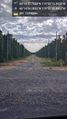
Hops! @46.2484,-119.8418
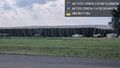
Hop harvest @46.2510,-119.8414
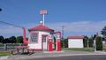
Teapot Dome


