Difference between revisions of "2020-03-22 55 13"
(Plans and location) |
m (→Location: spelling) |
||
| (2 intermediate revisions by 2 users not shown) | |||
| Line 3: | Line 3: | ||
| lon=13 | | lon=13 | ||
| date=2020-03-22 | | date=2020-03-22 | ||
| − | | graticule_name= | + | | graticule_name=Sövdeborg |
| graticule_link=Malmö, Sweden | | graticule_link=Malmö, Sweden | ||
}} | }} | ||
== Location == | == Location == | ||
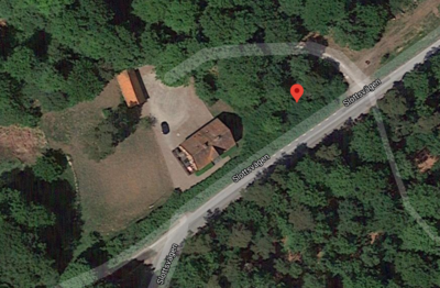
| − | The hash is in | + | The hash is in Sövdeborg, quite near the Sövdeborg castle. Looks like we can get somewhat close, but it might be on someones property, and also in bushes... |
[[File:2020_03_22_55_13_location_google.png|400px]] | [[File:2020_03_22_55_13_location_google.png|400px]] | ||
| Line 17: | Line 17: | ||
We'll take the car out for a spin, leaving Malmö around 12:30. We should be able to find parking by the castle and then we'll go by foot the rest of they way. | We'll take the car out for a spin, leaving Malmö around 12:30. We should be able to find parking by the castle and then we'll go by foot the rest of they way. | ||
| − | |||
== Expedition == | == Expedition == | ||
| + | The castle was a dud. The road leading up to it was not a public road and with nowhere else close to park we ended up stopping for a minute on the side of the road by the (private) road leading up to the land of the hash just get as close as possible. I took a screenshot of the geohash droid app, however asking Google Assistant to take a screenshot apparently doesn't actually save it anywhere, so that was lost. | ||
| − | + | With no place to park and eat our lunch, we drove north a bit to Sjöbo and had our lunch in a small foresty patch in the town. | |
== Photos == | == Photos == | ||
| − | <gallery | + | <gallery> |
| + | File:2020_03_22_55_13_castle_sign.jpg|We found the castle... | ||
| + | File:2020_03_22_55_13_private_road.jpg|But there was no access to it. | ||
| + | File:2020_03_22_55_13_almost_there.jpg|We're so close we can almost touch it! | ||
| + | File:2020_03_22_55_13_lunch.jpg|Giving up and eating some lunch | ||
</gallery> | </gallery> | ||
| − | |||
| − | |||
| − | |||
| − | |||
| − | |||
| − | |||
| − | |||
| − | |||
| − | |||
[[Category:Expeditions]] | [[Category:Expeditions]] | ||
| − | |||
[[Category:Expeditions with photos]] | [[Category:Expeditions with photos]] | ||
| − | |||
[[Category:Expedition without GPS]] | [[Category:Expedition without GPS]] | ||
| − | |||
| − | |||
| − | |||
| − | |||
| − | |||
| − | |||
| − | |||
[[Category:Coordinates not reached]] | [[Category:Coordinates not reached]] | ||
| − | |||
| − | |||
| − | |||
| − | |||
| − | |||
[[Category:Not reached - No public access]] | [[Category:Not reached - No public access]] | ||
| − | + | {{location|SE|M}} | |
| − | |||
| − | |||
| − | |||
| − | |||
| − | |||
| − | |||
| − | |||
Latest revision as of 15:33, 22 March 2020
| Sun 22 Mar 2020 in Sövdeborg: 55.5821801, 13.7054253 geohashing.info google osm bing/os kml crox |
Contents
Location
The hash is in Sövdeborg, quite near the Sövdeborg castle. Looks like we can get somewhat close, but it might be on someones property, and also in bushes...

Participants
gnuX Emeli
Plans
We'll take the car out for a spin, leaving Malmö around 12:30. We should be able to find parking by the castle and then we'll go by foot the rest of they way.
Expedition
The castle was a dud. The road leading up to it was not a public road and with nowhere else close to park we ended up stopping for a minute on the side of the road by the (private) road leading up to the land of the hash just get as close as possible. I took a screenshot of the geohash droid app, however asking Google Assistant to take a screenshot apparently doesn't actually save it anywhere, so that was lost.
With no place to park and eat our lunch, we drove north a bit to Sjöbo and had our lunch in a small foresty patch in the town.


