Difference between revisions of "2008-07-09 1 103"
From Geohashing
imported>Thomcat (Success/failure category added) |
imported>FippeBot m (Location) |
||
| (One intermediate revision by one other user not shown) | |||
| Line 22: | Line 22: | ||
[[Category:Expeditions with photos]] | [[Category:Expeditions with photos]] | ||
[[Category:Coordinates not reached]] | [[Category:Coordinates not reached]] | ||
| − | [[Category: | + | [[Category:Not reached - No public access]] |
| + | {{location|SG|SW}} | ||
Latest revision as of 05:46, 7 August 2019
| Wed 9 Jul 2008 in 1,103: 1.4053787, 103.7169733 geohashing.info google osm bing/os kml crox |
Expeditions
UnA
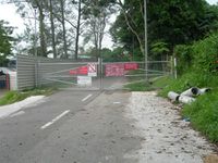
This is my inaugural attempt at geohashing. The meet up location was within a military training area but i went ahead hoping that there might be some units undergoing training thus i could sneak in. Started my cycling journey at about 1440 and reached the location at 1520 only to find the main gate locked. As it was a military training area, it would be unwise to attempt to bypass the gates. An interesting point point to note is that he locals in that area are known for sneaking in to harvest durians.
Waited for about 5 minutes for my GPS to acquired a signal and took a few pictures of the gate in the meantime. Judging from my GPS position, i was about 1.62km away from the actual meet up location. Better luck next time!
- Pictures

