Difference between revisions of "2022-01-05 37 -121"
(create 2022-01-05 37 -121) |
m (remove video category) |
||
| (4 intermediate revisions by 3 users not shown) | |||
| Line 1: | Line 1: | ||
| − | + | {{meetup graticule | |
| − | + | | lat=37 | |
| − | + | | lon=-121 | |
| − | + | | date=2022-01-05 | |
| − | + | }} | |
| − | |||
| − | |||
| − | |||
| − | |||
| − | | lat= | ||
| − | | lon= | ||
| − | | date= | ||
| − | }} | ||
__NOTOC__ | __NOTOC__ | ||
== Location == | == Location == | ||
| − | + | In between Almaden Quicksilver County Park and Calero County Park, both in San Jose, CA. | |
== Participants == | == Participants == | ||
| − | + | * [[User:Sporeball|sporeball]] | |
| − | |||
== Plans == | == Plans == | ||
| − | + | There are three options I saw that might have been suitable for accessing the hashpoint: | |
| + | * from Cinnabar Hills Road (probably blocked); | ||
| + | * by way of Via Vespero, The Cross Road, and some trail work (blocked at Via Vespero); | ||
| + | * using McKean Road to access Calero County Park itself, then performing a '''lot''' of trail work (very risky). | ||
| + | |||
| + | I made plans to travel by bicycle using one of these. | ||
== Expedition == | == Expedition == | ||
| − | + | After some deliberation, I decided to see how close I could get to the hashpoint by way of the first option, setting off at around 3:30 PM Pacific time. Bertram Road turned out to be accessible, and so did Cinnabar Hills! As my cell service started to die out, I thought I might still have a chance. | |
| − | + | There's a problem with the most uphill-oriented gear on either side of my bike that renders both unusable, so I inevitably had to get off and start walking. Just before 5:00 PM I finally had to stop: at a certain fork in the road, a metal gate blocks off one side, and a chain blocks off the other. This was disappointing, but I had still gotten much further than I expected to -- roughly half a mile away. A car exited through the gate as I stopped to eat, but I made no attempt to hail it. | |
| − | + | ||
| + | 3:30 PM turned out to be a bit late of a starting time for this expedition: I had received a new light for Christmas a week and a half prior to this expedition, but never put it on the bike, so most of the return trip would have to be helped by streetlight alone. A concerned woman shouted at me as I stopped on Almaden Road to put a jacket on, and, addressing her in my finest deadvoice (for volume's sake), I informed her that I was in fact fine, ''not'' lost, and not too tired, either. I got back home at about 6:15 PM, having traveled close to 25 miles in my attempt. | ||
== Photos == | == Photos == | ||
| − | |||
| − | |||
| − | |||
<gallery perrow="5"> | <gallery perrow="5"> | ||
| + | Image:2022 01 05 37 -121 proof.png | Proof of my location. | ||
| + | Image:2022 01 05 37 -121 chain.png | The chain that blocked me off. | ||
| + | Image:2022 01 05 37 -121 stopped.png | Stopping to eat. | ||
</gallery> | </gallery> | ||
== Achievements == | == Achievements == | ||
{{#vardefine:ribbonwidth|800px}} | {{#vardefine:ribbonwidth|800px}} | ||
| − | + | {{No trespassing | |
| + | | latitude = 37 | ||
| + | | longitude = -121 | ||
| + | | date = 2022-01-05 | ||
| + | | name = sporeball | ||
| + | }} | ||
| − | |||
| − | |||
| − | |||
| − | |||
| − | |||
| − | |||
| − | |||
| − | |||
| − | |||
| − | |||
| − | |||
| − | |||
| − | |||
| − | |||
[[Category:Expeditions]] | [[Category:Expeditions]] | ||
| − | |||
[[Category:Expeditions with photos]] | [[Category:Expeditions with photos]] | ||
| − | |||
| − | |||
| − | |||
| − | |||
| − | |||
| − | |||
| − | |||
| − | |||
| − | |||
[[Category:Coordinates not reached]] | [[Category:Coordinates not reached]] | ||
| − | |||
| − | |||
| − | |||
| − | |||
| − | |||
[[Category:Not reached - No public access]] | [[Category:Not reached - No public access]] | ||
| − | + | {{location|US|CA|SL}} | |
| − | |||
| − | |||
| − | |||
| − | |||
| − | |||
| − | |||
| − | |||
Latest revision as of 04:43, 6 January 2022
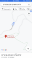
| Wed 5 Jan 2022 in 37,-121: 37.1717191, -121.8197048 geohashing.info google osm bing/os kml crox |
Location
In between Almaden Quicksilver County Park and Calero County Park, both in San Jose, CA.
Participants
Plans
There are three options I saw that might have been suitable for accessing the hashpoint:
- from Cinnabar Hills Road (probably blocked);
- by way of Via Vespero, The Cross Road, and some trail work (blocked at Via Vespero);
- using McKean Road to access Calero County Park itself, then performing a lot of trail work (very risky).
I made plans to travel by bicycle using one of these.
Expedition
After some deliberation, I decided to see how close I could get to the hashpoint by way of the first option, setting off at around 3:30 PM Pacific time. Bertram Road turned out to be accessible, and so did Cinnabar Hills! As my cell service started to die out, I thought I might still have a chance.
There's a problem with the most uphill-oriented gear on either side of my bike that renders both unusable, so I inevitably had to get off and start walking. Just before 5:00 PM I finally had to stop: at a certain fork in the road, a metal gate blocks off one side, and a chain blocks off the other. This was disappointing, but I had still gotten much further than I expected to -- roughly half a mile away. A car exited through the gate as I stopped to eat, but I made no attempt to hail it.
3:30 PM turned out to be a bit late of a starting time for this expedition: I had received a new light for Christmas a week and a half prior to this expedition, but never put it on the bike, so most of the return trip would have to be helped by streetlight alone. A concerned woman shouted at me as I stopped on Almaden Road to put a jacket on, and, addressing her in my finest deadvoice (for volume's sake), I informed her that I was in fact fine, not lost, and not too tired, either. I got back home at about 6:15 PM, having traveled close to 25 miles in my attempt.
Photos
Proof of my location.
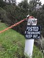
The chain that blocked me off.
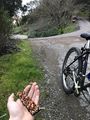
Stopping to eat.


Achievements
sporeball earned the No trespassing consolation prize
|