Difference between revisions of "2023-03-18 30 -97"
Sporksmith (talk | contribs) |
Sporksmith (talk | contribs) |
||
| (8 intermediate revisions by 2 users not shown) | |||
| Line 1: | Line 1: | ||
| + | [[Image:{{{image|PXL_20230318_171402973.jpg}}}|thumb|left]] | ||
| + | |||
{{meetup graticule | {{meetup graticule | ||
| lat=30 | | lat=30 | ||
| Line 18: | Line 20: | ||
The hash point was only a few miles away, so I rode my unicycle. Most of the route was familiar to me - it took me through a park I frequently ride to and in, and then a bit beyond into a neighborhood. | The hash point was only a few miles away, so I rode my unicycle. Most of the route was familiar to me - it took me through a park I frequently ride to and in, and then a bit beyond into a neighborhood. | ||
| − | I hoped | + | I hoped Google Maps wasn't quite right and that the hash point would be on the accessible side of the fence, but no such luck. I walked around the house to see if anyone was outside who I could ask for access. As luck would have it, someone pulled up just then. I briefly explained geohashing and asked if I could briefly visit their back yard and take a little video facing away from the house. They seemed on the fence initially, but politely declined when I mentioned taking video. In hindsight I should have just asked for access first and if they said yes *then* ask if photo and video were ok. C'est la vie. |
On the way back I stopped to take some [https://www.digitalmomblog.com/taking-bluebonnet-photos/ obligatory] [https://en.wikipedia.org/wiki/Lupinus_texensis Bluebonnet] photos. I also stopped in the park to practice juggling a little. I'd planned on doing it at the hash point for the circus achievement, but failing that figured I might as well still get some practice in. | On the way back I stopped to take some [https://www.digitalmomblog.com/taking-bluebonnet-photos/ obligatory] [https://en.wikipedia.org/wiki/Lupinus_texensis Bluebonnet] photos. I also stopped in the park to practice juggling a little. I'd planned on doing it at the hash point for the circus achievement, but failing that figured I might as well still get some practice in. | ||
| − | + | == Tracklog == | |
| + | <!-- if your GPS device keeps a log, you may use Template:Tracklog, post a link here, or both --> | ||
| + | |||
| + | {{ tracklog | 2023-03-18_30--97-sporksmith.gpx }} | ||
| + | |||
| + | == Photos == | ||
<gallery perrow="4"> | <gallery perrow="4"> | ||
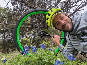
Image:PXL_20230318_171402973.jpg|Obligatory Bluebonnet selfie | Image:PXL_20230318_171402973.jpg|Obligatory Bluebonnet selfie | ||
| + | Image:2023-03-18-30--97-sporksmith-coordinates.jpg|Final coordinates | ||
</gallery> | </gallery> | ||
| + | |||
| + | == Video == | ||
| + | |||
| + | <youtube>nrlpUz9nL_E</youtube> | ||
| + | |||
| + | == Achievements == | ||
| + | {{#vardefine:ribbonwidth|100%}} | ||
| + | __NOTOC__ | ||
| + | |||
| + | {{No trespassing | ||
| + | | latitude = 30 | ||
| + | | longitude = -97 | ||
| + | | date = 2023-03-18 | ||
| + | | name = [[User:Sporksmith|sporksmith]] | ||
| + | | distance = 5m | ||
| + | }} | ||
[[Category:Expeditions]] | [[Category:Expeditions]] | ||
[[Category:Expeditions with photos]] | [[Category:Expeditions with photos]] | ||
| + | [[Category:Expeditions with videos]] | ||
[[Category:Coordinates not reached]] | [[Category:Coordinates not reached]] | ||
[[Category:Not reached - No public access]] | [[Category:Not reached - No public access]] | ||
| + | {{location|US|TX|TV}} | ||
Latest revision as of 19:55, 19 March 2023
| Sat 18 Mar 2023 in Austin: 30.4092984, -97.6887635 geohashing.info google osm bing/os kml crox |
Location
Just inside a private back yard, on the other side of a fence from an accessible power line cut.
Participants
Expedition
The hash point was only a few miles away, so I rode my unicycle. Most of the route was familiar to me - it took me through a park I frequently ride to and in, and then a bit beyond into a neighborhood.
I hoped Google Maps wasn't quite right and that the hash point would be on the accessible side of the fence, but no such luck. I walked around the house to see if anyone was outside who I could ask for access. As luck would have it, someone pulled up just then. I briefly explained geohashing and asked if I could briefly visit their back yard and take a little video facing away from the house. They seemed on the fence initially, but politely declined when I mentioned taking video. In hindsight I should have just asked for access first and if they said yes *then* ask if photo and video were ok. C'est la vie.
On the way back I stopped to take some obligatory Bluebonnet photos. I also stopped in the park to practice juggling a little. I'd planned on doing it at the hash point for the circus achievement, but failing that figured I might as well still get some practice in.
Tracklog
Photos
Video
Achievements
sporksmith earned the No trespassing consolation prize
|


