Difference between revisions of "2024-08-05 47 7"
Coyotebush (talk | contribs) ([retro picture]Kleines Engländerdenkmal [https://openstreetmap.org/?mlat=47.91205000&mlon=7.91010278&zoom=16 @47.9120,7.9101]) |
m (Location) |
||
| (4 intermediate revisions by one other user not shown) | |||
| Line 13: | Line 13: | ||
== Plans == | == Plans == | ||
| − | I've seen Schauinslandbahn advertised as a local attraction, but wasn't sure how or when to make the most of it. | + | I've seen Schauinslandbahn advertised as a local attraction, but wasn't sure how or when to make the most of it. The algorithm provided an answer! |
Bus to Horben (covered by Deutschlandticket), Schauinslandbahn gondola to the top (separate ticket), hike around. <s>Or maybe start with a bus to somewhere between Oberried and Hofsgrund, for variety and so that the hike is all uphill.</s> Never mind, I don't think you can buy Schauinslandbahn tickets at the top. | Bus to Horben (covered by Deutschlandticket), Schauinslandbahn gondola to the top (separate ticket), hike around. <s>Or maybe start with a bus to somewhere between Oberried and Hofsgrund, for variety and so that the hike is all uphill.</s> Never mind, I don't think you can buy Schauinslandbahn tickets at the top. | ||
| Line 23: | Line 23: | ||
*Transferring from tram to bus -- [[User:Coyotebush|Coyotebush]] ([[User talk:Coyotebush|talk]]) [https://openstreetmap.org/?mlat=47.96439049&mlon=7.85771516&zoom=16 @47.9644,7.8577] 10:23, 5 August 2024 (GMT+02:00) | *Transferring from tram to bus -- [[User:Coyotebush|Coyotebush]] ([[User talk:Coyotebush|talk]]) [https://openstreetmap.org/?mlat=47.96439049&mlon=7.85771516&zoom=16 @47.9644,7.8577] 10:23, 5 August 2024 (GMT+02:00) | ||
| − | The gondola station sold us all tickets and filled gondolas to their capacity of 7, so the 5 already mentioned were joined by an older duo for the 20-minute ascent. | + | The gondola station sold us all round-trip tickets and filled gondolas to their capacity of 7, so the 5 already mentioned were joined by an older duo for the 20-minute ascent. |
Definitely cooler at the top - almost chilly under some clouds. I paid visits to the restroom and snack stand first (also noting a ticket booth), then had Google Maps chart a route to the hashpoint. | Definitely cooler at the top - almost chilly under some clouds. I paid visits to the restroom and snack stand first (also noting a ticket booth), then had Google Maps chart a route to the hashpoint. | ||
*Finally ready to hike -- [[User:Coyotebush|Coyotebush]] ([[User talk:Coyotebush|talk]]) [https://openstreetmap.org/?mlat=47.90947021&mlon=7.89144605&zoom=16 @47.9095,7.8914] 11:40, 5 August 2024 (GMT+02:00) | *Finally ready to hike -- [[User:Coyotebush|Coyotebush]] ([[User talk:Coyotebush|talk]]) [https://openstreetmap.org/?mlat=47.90947021&mlon=7.89144605&zoom=16 @47.9095,7.8914] 11:40, 5 August 2024 (GMT+02:00) | ||
| + | |||
| + | First decision was to go over the summit instead of around, in hopes of a good view of the whole area. However, the tower at the summit was closed and clouds obscured the distant view. Nice views into the valley to the south began though. | ||
| + | |||
| + | Then I worried that Google was counting on routing past the observatory through a very closed gate, but it was actually using the path around. Construction work in progress at the air monitoring station, then the path dwindled across a large meadow before re-entering forest. More downhill than my knees had hoped for and only one other pair of hikers past the meadow. | ||
| + | |||
| + | Back to driveable gravel roads, where navigation insisted on a shortcut through tall grasses and I had to look for an easier route. Once Google Maps reached the nearest road point, I tried to find relatively clear areas that had been apparent in aerial imagery. Conveniently, a particularly low line of grass gave way to an open forest sloping gently down towards the point. | ||
| + | |||
| + | For the return hike, I opted for an alternate route starting by continuing on the same gravel road. The route then led to a somewhat overgrown road/trail and eventually to a junction near one of the memorials to the [[wikipedia:English calamity|English calamity]]. Google and OSM indicate a path just below the ridge to past the observatory, but from imagery and previous observation this was mostly cow pasture, and the official hiking signs pointed me up to the ridge, so I took that sharp right turn. | ||
| + | |||
| + | Visited the summit again since clouds had cleared, improving the view. Back to the snack stand for more substantial fare, where at one point my original group of 5 was together in line. Enjoyed the views for a while before descending. | ||
*Back down again -- [[User:Coyotebush|Coyotebush]] ([[User talk:Coyotebush|talk]]) [https://openstreetmap.org/?mlat=47.93624845&mlon=7.86485600&zoom=16 @47.9362,7.8649] 15:31, 5 August 2024 (GMT+02:00) | *Back down again -- [[User:Coyotebush|Coyotebush]] ([[User talk:Coyotebush|talk]]) [https://openstreetmap.org/?mlat=47.93624845&mlon=7.86485600&zoom=16 @47.9362,7.8649] 15:31, 5 August 2024 (GMT+02:00) | ||
| + | |||
| + | The return bus was not remotely on schedule and pulled in just as a tram departed, but carried us 5 yet again among many others. | ||
== Tracklog == | == Tracklog == | ||
| Line 61: | Line 73: | ||
Image:2024-08-05_47_7_coyotebush_1723222215931.jpg|Closest part of the trail [https://openstreetmap.org/?mlat=47.91973333&mlon=7.91916389&zoom=16 @47.9197,7.9192] | Image:2024-08-05_47_7_coyotebush_1723222215931.jpg|Closest part of the trail [https://openstreetmap.org/?mlat=47.91973333&mlon=7.91916389&zoom=16 @47.9197,7.9192] | ||
| − | Image:2024-08- | + | Image:2024-08-05_47_7_coyotebush_1723222420293.jpg|Panorama at the point |
Image:2024-08-05_47_7_coyotebush_1723222314042.jpg|Grin [https://openstreetmap.org/?mlat=47.92008333&mlon=7.91984167&zoom=16 @47.9201,7.9198] | Image:2024-08-05_47_7_coyotebush_1723222314042.jpg|Grin [https://openstreetmap.org/?mlat=47.92008333&mlon=7.91984167&zoom=16 @47.9201,7.9198] | ||
| Line 67: | Line 79: | ||
Image:2024-08-05_47_7_coyotebush_1723222368157.jpg|Map screenshot | Image:2024-08-05_47_7_coyotebush_1723222368157.jpg|Map screenshot | ||
| − | Image:2024-08- | + | Image:2024-08-05_47_7_coyotebush_1723222481062.jpg|Kleines Engländerdenkmal [https://openstreetmap.org/?mlat=47.91205000&mlon=7.91010278&zoom=16 @47.9120,7.9101] |
| + | |||
| + | Image:2024-08-05_47_7_coyotebush_1723222685162.jpg|Watching gondolas and a paraglider [https://openstreetmap.org/?mlat=47.90996111&mlon=7.89138611&zoom=16 @47.9100,7.8914] | ||
| − | Image:2024-08- | + | Image:2024-08-05_47_7_coyotebush_1723222735296.jpg|Paraglider near gondola station [https://openstreetmap.org/?mlat=47.91005556&mlon=7.89115556&zoom=16 @47.9101,7.8912] |
</gallery> | </gallery> | ||
| − | |||
== Achievements == | == Achievements == | ||
{{#vardefine:ribbonwidth|100%}} | {{#vardefine:ribbonwidth|100%}} | ||
| + | |||
| + | {{Public transport geohash | latitude = 47 | longitude = 7 | date = 2024-08-05 | name = coyotebush | busline = the Schauinslandbahn | image = 2024-08-05 47 7 coyotebush 1722951147054.jpg }} | ||
__NOTOC__ | __NOTOC__ | ||
| − | |||
| − | |||
| − | |||
[[Category:Expeditions]] | [[Category:Expeditions]] | ||
[[Category:Expeditions with photos]] | [[Category:Expeditions with photos]] | ||
[[Category:Coordinates reached]] | [[Category:Coordinates reached]] | ||
| − | + | {{location|DE|BW|FR}} | |
| − | |||
| − | |||
| − | |||
| − | |||
| − | |||
| − | |||
| − | |||
Latest revision as of 18:42, 10 August 2024
| Mon 5 Aug 2024 in 47,7: 47.9200070, 7.9197153 geohashing.info google osm bing/os kml crox |
Location
On the east side of the Schauinsland mountain.
Participants
Plans
I've seen Schauinslandbahn advertised as a local attraction, but wasn't sure how or when to make the most of it. The algorithm provided an answer!
Bus to Horben (covered by Deutschlandticket), Schauinslandbahn gondola to the top (separate ticket), hike around. Or maybe start with a bus to somewhere between Oberried and Hofsgrund, for variety and so that the hike is all uphill. Never mind, I don't think you can buy Schauinslandbahn tickets at the top.
Expedition
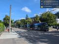
In Freiburg, clouds were starting to clear, letting through a hot sun. Good day to seek cooler temperatures at altitude. Google Maps sent me on the number 2 tram to the number 21 bus in order to reach the lower gondola station. It turns out the bus route begins exactly where the tram tracks end, fairly far out a valley. Also navigating this transfer with me were another solo tourist and a grandmother with two grandchildren.
- Transferring from tram to bus -- Coyotebush (talk) @47.9644,7.8577 10:23, 5 August 2024 (GMT+02:00)
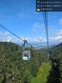
The gondola station sold us all round-trip tickets and filled gondolas to their capacity of 7, so the 5 already mentioned were joined by an older duo for the 20-minute ascent.
Definitely cooler at the top - almost chilly under some clouds. I paid visits to the restroom and snack stand first (also noting a ticket booth), then had Google Maps chart a route to the hashpoint.
- Finally ready to hike -- Coyotebush (talk) @47.9095,7.8914 11:40, 5 August 2024 (GMT+02:00)
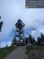
First decision was to go over the summit instead of around, in hopes of a good view of the whole area. However, the tower at the summit was closed and clouds obscured the distant view. Nice views into the valley to the south began though.
Then I worried that Google was counting on routing past the observatory through a very closed gate, but it was actually using the path around. Construction work in progress at the air monitoring station, then the path dwindled across a large meadow before re-entering forest. More downhill than my knees had hoped for and only one other pair of hikers past the meadow.
Back to driveable gravel roads, where navigation insisted on a shortcut through tall grasses and I had to look for an easier route. Once Google Maps reached the nearest road point, I tried to find relatively clear areas that had been apparent in aerial imagery. Conveniently, a particularly low line of grass gave way to an open forest sloping gently down towards the point.
For the return hike, I opted for an alternate route starting by continuing on the same gravel road. The route then led to a somewhat overgrown road/trail and eventually to a junction near one of the memorials to the English calamity. Google and OSM indicate a path just below the ridge to past the observatory, but from imagery and previous observation this was mostly cow pasture, and the official hiking signs pointed me up to the ridge, so I took that sharp right turn.
Visited the summit again since clouds had cleared, improving the view. Back to the snack stand for more substantial fare, where at one point my original group of 5 was together in line. Enjoyed the views for a while before descending.
- Back down again -- Coyotebush (talk) @47.9362,7.8649 15:31, 5 August 2024 (GMT+02:00)
The return bus was not remotely on schedule and pulled in just as a tram departed, but carried us 5 yet again among many others.
Tracklog
Photos
Tram to bus transfer @47.9643,7.8578
A nice view while ascending @47.9198,7.8810

Could have bought a descent-only ticket at the top. Too bad I couldn't figure that out online @47.9099,7.8915
Summit tower closed @47.9117,7.8983
Observatory @47.9127,7.9039
Cows and construction at the air monitoring station @47.9135,7.9068
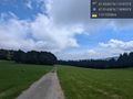
Meadow @47.9144,7.9091
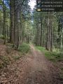
Forest trail @47.9170,7.9153
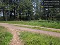
"continue straight ahead" @47.9194,7.9170
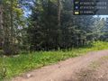
Closest part of the trail @47.9197,7.9192
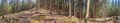
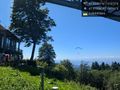
Panorama at the point
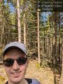
Grin @47.9201,7.9198
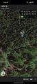
Map screenshot
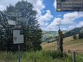
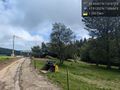
Kleines Engländerdenkmal @47.9120,7.9101
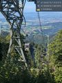
Watching gondolas and a paraglider @47.9100,7.8914
Paraglider near gondola station @47.9101,7.8912


Achievements
coyotebush earned the Public transport geohash achievement
|