Difference between revisions of "2024-08-25 65 30"
| Line 1: | Line 1: | ||
| − | + | {{meetup graticule|date=2024-08-25|lat=65|lon=30}} | |
| − | |||
| − | |||
| − | |||
| − | |||
| − | |||
| − | |||
| − | |||
| − | |||
== Location == | == Location == | ||
In a forest near lake Peurajärvi, Kuusamo. | In a forest near lake Peurajärvi, Kuusamo. | ||
| Line 18: | Line 10: | ||
== Expedition == | == Expedition == | ||
Success! Report will follow... | Success! Report will follow... | ||
| + | |||
| + | Finally, an accessible point for me in this difficult graticule! There is only a 1.9% probability that a random point in it hits a part of Finland that is not border zone, which means that there are on average about seven accessible hashpoints per year. Only three of them are expected to be on days when I could realistically have an expedition without skipping work (Friday to Sunday), and half of the time it is snowy season when access to terrain is difficult but getting to lakes may be easier. Therefore, I can expect about two doable hashpoints per year, and this happened to be a lucky day since it was a summer Sunday. | ||
| + | |||
| + | After I noticed this hashpoint on Friday, Fiancée and I had a discussion and decided to do an ex tempore visit to her parents in Kuusamo. We drove there on Saturday, and I went adventuring on Sunday forenoon after breakfast. Getting to the hashpoint would require driving about 60 kilometers and walking a few kilometres. There was a road that went much closer than that, but it would likely be a private road with access forbidden for outsiders. | ||
== Tracklog == | == Tracklog == | ||
Latest revision as of 14:44, 25 August 2024
| Sun 25 Aug 2024 in 65,30: 65.7538654, 30.0136727 geohashing.info google osm bing/os kml crox |
Location
In a forest near lake Peurajärvi, Kuusamo.
The point on a topographic map: [1]
Participants
Expedition
Success! Report will follow...
Finally, an accessible point for me in this difficult graticule! There is only a 1.9% probability that a random point in it hits a part of Finland that is not border zone, which means that there are on average about seven accessible hashpoints per year. Only three of them are expected to be on days when I could realistically have an expedition without skipping work (Friday to Sunday), and half of the time it is snowy season when access to terrain is difficult but getting to lakes may be easier. Therefore, I can expect about two doable hashpoints per year, and this happened to be a lucky day since it was a summer Sunday.
After I noticed this hashpoint on Friday, Fiancée and I had a discussion and decided to do an ex tempore visit to her parents in Kuusamo. We drove there on Saturday, and I went adventuring on Sunday forenoon after breakfast. Getting to the hashpoint would require driving about 60 kilometers and walking a few kilometres. There was a road that went much closer than that, but it would likely be a private road with access forbidden for outsiders.
Tracklog
Photos
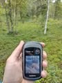
Proof of location.
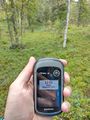
Proof of date and time.


Achievements
Kripakko earned the Land geohash achievement
|
Kripakko earned the Graticule Unlocked Achievement
|