Difference between revisions of "2024-09-25 41 -84"
From Geohashing
([live] temp) |
|||
| (3 intermediate revisions by 2 users not shown) | |||
| Line 1: | Line 1: | ||
| − | + | {{meetup graticule|date=2024-09-25|lat=41|lon=-84}} | |
| − | |||
| − | |||
| − | |||
| − | |||
| − | |||
| − | |||
| − | |||
| − | |||
== Location == | == Location == | ||
| − | + | This Geohash is located at the edge of a forest next to a road outside of Angola. | |
== Participants == | == Participants == | ||
| − | + | *[[User:Ironeagl|Ironeagl]] | |
| − | |||
| − | |||
| − | |||
| − | |||
== Expedition == | == Expedition == | ||
<!-- how it all turned out. your narrative goes here. --> | <!-- how it all turned out. your narrative goes here. --> | ||
| − | + | Upon reaching the point of the road that was closest to the hashpoint, I discovered that it was in fact 5m off the road, in the middle of a large bush. No Tresspassing signs were posted nearby and in front of the bush, so... | |
| − | |||
| − | |||
| − | |||
| − | |||
| − | |||
== Photos == | == Photos == | ||
| Line 32: | Line 15: | ||
--> | --> | ||
<gallery perrow="5"> | <gallery perrow="5"> | ||
| + | Image:2024-09-25_th-hashpoint.jpg | So close, and yet so far... | ||
</gallery> | </gallery> | ||
| Line 39: | Line 23: | ||
__NOTOC__ | __NOTOC__ | ||
| − | |||
| − | |||
| − | |||
| − | |||
| − | |||
| − | |||
| − | |||
| − | |||
| − | |||
| − | |||
[[Category:Expeditions]] | [[Category:Expeditions]] | ||
| − | + | <!-- | |
[[Category:Expeditions with photos]] | [[Category:Expeditions with photos]] | ||
[[Category:Expeditions with videos]] | [[Category:Expeditions with videos]] | ||
--> | --> | ||
| − | |||
| − | |||
| − | |||
| − | |||
| − | |||
[[Category:Coordinates not reached]] | [[Category:Coordinates not reached]] | ||
| − | |||
| − | |||
| − | |||
| − | |||
| − | |||
[[Category:Not reached - No public access]] | [[Category:Not reached - No public access]] | ||
| − | + | {{location|US|IN|SE}} | |
| − | |||
| − | |||
| − | |||
| − | |||
Latest revision as of 02:16, 2 November 2024
| Wed 25 Sep 2024 in 41,-84: 41.6210680, -84.9834654 geohashing.info google osm bing/os kml crox |
Location
This Geohash is located at the edge of a forest next to a road outside of Angola.
Participants
Expedition
Upon reaching the point of the road that was closest to the hashpoint, I discovered that it was in fact 5m off the road, in the middle of a large bush. No Tresspassing signs were posted nearby and in front of the bush, so...
Photos
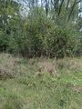
So close, and yet so far...
