Difference between revisions of "User:CaptainSpam"
imported>CaptainSpam (Added an expedition!) |
imported>CaptainSpam (New expedition!) |
||
| Line 6: | Line 6: | ||
* [[2010-04-04_42_-82]] - Wherein I travel to a strip mall in the Baker College area of Clinton Township, MI. | * [[2010-04-04_42_-82]] - Wherein I travel to a strip mall in the Baker College area of Clinton Township, MI. | ||
* [[2011-05-01_38_-84]] - Wherein I drive along an otherwise unassuming stretch of I-64 somewhere east of Lexington, KY. | * [[2011-05-01_38_-84]] - Wherein I drive along an otherwise unassuming stretch of I-64 somewhere east of Lexington, KY. | ||
| + | * [[2011-06-01 38 -84]] - Wherein I visit a strip mall that contains a Kroger's in Lexington, KY. | ||
== Pictures == | == Pictures == | ||
| Line 20: | Line 21: | ||
Image:2010-04-04_42_-82_16-01-16-596.jpg | The corner of 15 Mile Road and Little Mack. [http://www.openstreetmap.org/?lat=42.5546&lon=-82.9111&zoom=16&layers=B000FTF @42.5546,-82.9111] | Image:2010-04-04_42_-82_16-01-16-596.jpg | The corner of 15 Mile Road and Little Mack. [http://www.openstreetmap.org/?lat=42.5546&lon=-82.9111&zoom=16&layers=B000FTF @42.5546,-82.9111] | ||
Image:2010-04-04_42_-82_16-02-27-483.jpg | The point itself. There's a residential area right behind it. [http://www.openstreetmap.org/?lat=42.5552&lon=-82.9115&zoom=16&layers=B000FTF @42.5552,-82.9115] | Image:2010-04-04_42_-82_16-02-27-483.jpg | The point itself. There's a residential area right behind it. [http://www.openstreetmap.org/?lat=42.5552&lon=-82.9115&zoom=16&layers=B000FTF @42.5552,-82.9115] | ||
| + | Image:2011-06-01_38_-84_20-10-11-877.jpg | Welcome to the corner of Richmond and Man O' War! There's a Kroger's here! [http://www.openstreetmap.org/?lat=38.0020&lon=-84.4465&zoom=16&layers=B000FTF @38.0020,-84.4465] | ||
| + | Image:2011-06-01_38_-84_20-11-10-862.jpg | This car (not mine) is parked right on the point. Curses! So close! [http://www.openstreetmap.org/?lat=38.0035&lon=-84.4458&zoom=16&layers=B000FTF @38.0035,-84.4458] | ||
| + | Image:2011-06-01_38_-84_20-11-55-728.jpg | Compare my car, parked right nearby. [http://www.openstreetmap.org/?lat=38.0035&lon=-84.4458&zoom=16&layers=B000FTF @38.0035,-84.4458] | ||
| + | Image:2011-06-01_38_-84_20-13-19-092.jpg | The main attraction of this corner is this Kroger's. [http://www.openstreetmap.org/?lat=38.0035&lon=-84.4457&zoom=16&layers=B000FTF @38.0035,-84.4457] | ||
</gallery> | </gallery> | ||
Revision as of 01:22, 2 June 2011
Hi! I'm CaptainSpam. You might know me as the guy who coded Geohash Droid. Chances are you don't, but you might. My current home graticule is 38N 84W, servicing Lexington, KY, though since I live on the very southern border, I may wind up a graticule south.
Expeditions
- 2009-05-07_38_-84 - Wherein I visit Constitution Park in Lexington, KY.
- 2010-04-04_42_-82 - Wherein I travel to a strip mall in the Baker College area of Clinton Township, MI.
- 2011-05-01_38_-84 - Wherein I drive along an otherwise unassuming stretch of I-64 somewhere east of Lexington, KY.
- 2011-06-01 38 -84 - Wherein I visit a strip mall that contains a Kroger's in Lexington, KY.
Pictures
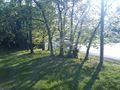
The entrance to Constitution Park.
Small shot of the road on which the point rested.
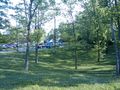
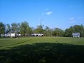
Busy day at Constitution Park, it seems. And more shots of trees.
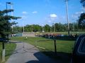
A ball game in progress! So that's what was going on.
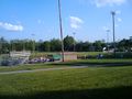
Another baseball angle. You can't read it from here, but the score was 2-1, whoever the visitor was.
The people were not, however, ready for some football. Nice field, though.
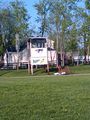
More detail on the tower. I'm surprised they didn't go with the Bengals, as they're a bit closer.
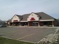
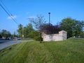
The strip mall behind which the April 4, 2010 42,-82 point sat. @42.5546,-82.9115
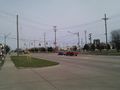
The corner of 15 Mile Road and Little Mack. @42.5546,-82.9111
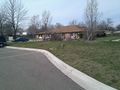
The point itself. There's a residential area right behind it. @42.5552,-82.9115
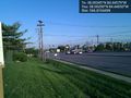
Welcome to the corner of Richmond and Man O' War! There's a Kroger's here! @38.0020,-84.4465
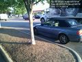
This car (not mine) is parked right on the point. Curses! So close! @38.0035,-84.4458
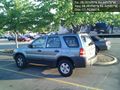
Compare my car, parked right nearby. @38.0035,-84.4458
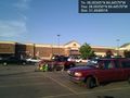
The main attraction of this corner is this Kroger's. @38.0035,-84.4457


