Difference between revisions of "2009-07-05 49 10"
From Geohashing
imported>Thepiguy (That's all I remember.) |
imported>Thepiguy (First pictures from July! I have a lot of catching up to do.) |
||
| Line 18: | Line 18: | ||
==Images== | ==Images== | ||
| − | " | + | <gallery> |
| + | Image:2009-07-05_49_10_zomg_sun.jpg|This is going to be fun... | ||
| + | Image:2009-07-05_49_10_zomg_heat.jpg|It was bout here I realized my half a bottle of water was <i>not</i> going to cut it. | ||
| + | Image:2009-07-05_49_10_not_path.jpg|"Allright GPS, when we get back home we're having a nice long chat about what <i>does</i> and <i>does not</i> constitute a road!" | ||
| + | Image:2009-07-05_49_10_still_not_path.jpg|What did I just say?!? | ||
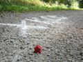
| + | Image:2009-07-05 49 10 hash.jpg|Not only <i>does</i> this qualify as a road, but it is <i>not</i> in the GPS. Also, it's the hashpoint. | ||
| + | Image:2009-07-05_49_10_murray.jpg|Murray at the hashpoint. | ||
| + | Image:2009-07-05_49_10_gps.jpg|I can't think up anything to say about this picture. There are som many of them. | ||
| + | Image:2009-07-05_49_10_frog.jpg|Hash frog! | ||
| + | </gallery> | ||
Revision as of 18:41, 21 July 2009
| Sun 5 Jul 2009 in Bamberg: 49.3518423, 10.1062209 geohashing.info google osm bing/os kml crox |
Location
On a bike path south west of Ochsenfurt.
Participants
Expedition
It was a short yet grueling bike ride that involved sun, heat, questionable GPS directions, more sun, and a lack of water.
Images
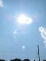
This is going to be fun...

It was bout here I realized my half a bottle of water was not going to cut it.
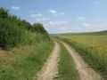
"Allright GPS, when we get back home we're having a nice long chat about what does and does not constitute a road!"
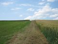
What did I just say?!?
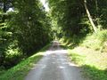
Not only does this qualify as a road, but it is not in the GPS. Also, it's the hashpoint.
Murray at the hashpoint.
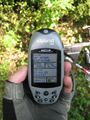
I can't think up anything to say about this picture. There are som many of them.
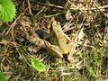
Hash frog!


