Difference between revisions of "2009-07-11 48 10"
imported>Tomcat (New page: {{meetup graticule | map=<map lat="48" lon="10" date="2009-07-11" /> | lat=48 | lon=10 | date=2009-07-11 | graticule_name=Augsburg, Germany | graticule_link=Augsburg, Germany}} == Expediti...) |
imported>Dawidi m (+Category:Expeditions ... and, i wouldn't mind if you counted that one as reached...) |
||
| Line 14: | Line 14: | ||
Unfortunately, at the moment we began to take pictures from the track west of the field, the farmer came up with his tractor and started to bring out some chemicals on the field. So - to avoid any discussion - we gave up our plan to reach the exact coordinates and instead walked on the southern edge of the carrotfield as near as possible to the exact spot that turned out to be a distance of 15m. | Unfortunately, at the moment we began to take pictures from the track west of the field, the farmer came up with his tractor and started to bring out some chemicals on the field. So - to avoid any discussion - we gave up our plan to reach the exact coordinates and instead walked on the southern edge of the carrotfield as near as possible to the exact spot that turned out to be a distance of 15m. | ||
| − | |||
== Photos == | == Photos == | ||
| − | |||
<gallery> | <gallery> | ||
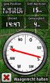
Image:2009-07-11_48_10_GPS.jpg | coords not reached | Image:2009-07-11_48_10_GPS.jpg | coords not reached | ||
| Line 23: | Line 21: | ||
</gallery> | </gallery> | ||
| + | [[Category:Expeditions]] | ||
[[Category:Expeditions with photos]] | [[Category:Expeditions with photos]] | ||
[[Category:Coordinates not reached]] | [[Category:Coordinates not reached]] | ||
Revision as of 13:34, 12 July 2009
| Sat 11 Jul 2009 in Augsburg, Germany: 48.3206566, 10.1604565 geohashing.info google osm bing/os kml crox |
Expedition
The hashpoint was situated in a field between Attenhofen and Hegelhofen, about 15 km southeast of Ulm.
Since we had been in that area today anyway, we decided to visit that hash too.
Approaching the coordinates via the farmtrack west of the point from the south, we realized that the point happened to be in a carrotfield, that would mean that the coordinates would be reachable by stepping over the rows of plants without trampling down any of them.
Unfortunately, at the moment we began to take pictures from the track west of the field, the farmer came up with his tractor and started to bring out some chemicals on the field. So - to avoid any discussion - we gave up our plan to reach the exact coordinates and instead walked on the southern edge of the carrotfield as near as possible to the exact spot that turned out to be a distance of 15m.
Photos
coords not reached

360° panoramic view at the hash.
