Difference between revisions of "2009-08-10 50 7"
From Geohashing
imported>FippeBot m (Location) |
m |
||
| Line 25: | Line 25: | ||
[[Category:Expeditions with photos]] | [[Category:Expeditions with photos]] | ||
[[Category:Coordinates not reached]] | [[Category:Coordinates not reached]] | ||
| + | [[Category:Not reached - No public access]] | ||
{{location|DE|NW|SU}} | {{location|DE|NW|SU}} | ||
Latest revision as of 09:57, 25 April 2022
| Mon 10 Aug 2009 in 50,7: 50.8559601, 7.4619887 geohashing.info google osm bing/os kml crox |
Location
This geohashing point is located in the middle of a corn field, with few houses around it. The next bigger village is called Ruppichteroth.
Expedition: Dataflash
This was my first geohashing. I wanted to drive around with my motorbike, but I had absolutely no idea where to drive. So I decided to let geohashing decide, where I'll drive. It took me along a lot of fields, cows and a lot of farms across the so called "Bergisches Land". I decided that the owner of this corn field might not be that happy if i walk across his field, so I got 15m next to the point.
-- Jan
- Photo Gallery
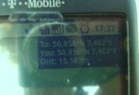
The Proof. Geohash Droid is a nice app for the G1.
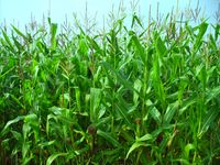
15 meters in this field lays the point.
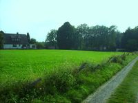
The area around the point.

Some more area around.

Geohashing by motorbike is fun.


