Difference between revisions of "2009-11-09 60 24"
From Geohashing
imported>Hanpet (→The Location) |
imported>Jiml m (Expand Template) |
||
| Line 20: | Line 20: | ||
Image:DSC02092.JPG | Geohasher | Image:DSC02092.JPG | Geohasher | ||
</gallery> | </gallery> | ||
| + | |||
| + | |||
| + | |||
| + | <!-- If you did not specify these parameters in the template, please substitute appropriate things for IMAGE, LAT, LON, and DATE (YYYY-MM-DD format) | ||
| + | |||
| + | [[Image:{{{image|IMAGE}}}|thumb|left]] | ||
| + | |||
| + | And DON'T FORGET to add your expedition and the best photo you took to the gallery on the Main Page! We'd love to read your report, but that means we first have to discover it! | ||
| + | --> | ||
| + | {{meetup graticule | ||
| + | | lat=60 | ||
| + | | lon=24 | ||
| + | | date=2009-11-09 | ||
| + | }} | ||
| + | |||
| + | <!-- edit as necessary --> | ||
| + | __NOTOC__ | ||
| + | == Location == | ||
| + | |||
| + | |||
| + | == Participants == | ||
| + | |||
| + | |||
| + | == Plans == | ||
| + | |||
| + | |||
| + | == Expedition == | ||
| + | |||
| + | |||
| + | == Tracklog == | ||
| + | |||
| + | |||
| + | == Photos == | ||
| + | |||
| + | <!-- Insert pictures between the gallery tags using the following format: | ||
| + | <gallery perrow="4"> | ||
| + | Image:2009-##-## ## ## Alpha.jpg | Witty Comment | ||
| + | Image:2009-##-## ## ## Beta.jpg | Witty Comment | ||
| + | </gallery> | ||
| + | --> | ||
| + | |||
| + | |||
| + | <!-- Delete the next line ONLY if you have chosen the appropriate categories below. If you are unsure, don't worry. People will read your report and help you with the classification. --> | ||
| + | [[Category:New report]] | ||
| + | |||
| + | <!-- Potential categories. Please include all the ones appropriate to your expedition --> | ||
| + | <!-- If this is a planning page: | ||
| + | [[Category:Expedition planning]] | ||
| + | --> | ||
| + | |||
| + | <!-- An actual expedition: | ||
| + | [[Category:Expeditions]] | ||
| + | -- and one or more of -- | ||
| + | [[Category:Expeditions with photos]] | ||
| + | [[Category:Expeditions with videos]] | ||
| + | [[Category:Expedition without GPS]] | ||
| + | --> | ||
| + | |||
| + | <!-- if you reached your coords: | ||
| + | [[Category:Coordinates reached]] | ||
| + | --> | ||
| + | |||
| + | <!-- or if you failed :( | ||
| + | [[Category:Coordinates not reached]] | ||
| + | -- and a reason -- | ||
| + | [[Category:Not reached - Mother Nature]] | ||
| + | [[Category:Not reached - No public access]] | ||
| + | [[Category:Not reached - Technology]] | ||
| + | [[Category:Failed - Did not attempt]] | ||
| + | --> | ||
Revision as of 16:20, 10 January 2010
The Location
In Koskelo, Espoo. Just outside of Ring 3.
The Participants
Only one geohasher team turned up.
The Expedition and Photos
Today's hash point was about 7 km from our home as crow flies and it fell near the junction of two roads. The point was very easily reached. We parked our car nearby (no "Public transport achievements" today...) and jumped over the ditch. It was about 6 pm and already dark. The weather was a bit foggy too, so the pictures below aren't very good.
From the hashpoint we continued to starting point of mystery geocache nearby.
This was our first time geohashing. We wouldn't know about this game unless Mikkozzz introduced it to us.
The hashpoint
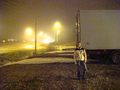
Geohasher


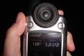
| Mon 9 Nov 2009 in 60,24: 60.2645986, 24.7287152 geohashing.info google osm bing/os kml crox |
Location
Participants
Plans
Expedition
Tracklog
Photos