Difference between revisions of "2010-05-17 -36 146"
From Geohashing
imported>Jiml m (Expand Template) |
imported>Jiml m (Fill in what is known) |
||
| Line 1: | Line 1: | ||
| − | |||
| − | |||
| − | |||
| − | |||
| − | |||
| − | |||
| − | |||
<!-- If you did not specify these parameters in the template, please substitute appropriate things for IMAGE, LAT, LON, and DATE (YYYY-MM-DD format) | <!-- If you did not specify these parameters in the template, please substitute appropriate things for IMAGE, LAT, LON, and DATE (YYYY-MM-DD format) | ||
| Line 31: | Line 24: | ||
== Expedition == | == Expedition == | ||
<!-- how it all turned out. your narrative goes here. --> | <!-- how it all turned out. your narrative goes here. --> | ||
| + | |||
| + | |||
| + | [[user:Kieran|Kieran]], having just finished night shift, decided to go geohashing. Now to switch to first person. It was an "Eleventh Commandment" geohash as I crept down a farm track right next to a farm house. | ||
| + | |||
| + | I navigated to where I thought the has should be according to Google Maps landmarks and then checked the GPS. I had the longitute right, the latitude was out by about a kilometre. The map below shows how far out I was. | ||
| + | |||
| + | * [http://www.youtube.com/watch?v=_bjYLdPlYPU Video report from the hash]. | ||
| + | |||
| + | If only I could figure out how to embed youtube in this wiki. | ||
| + | |||
| + | |||
== Tracklog == | == Tracklog == | ||
| Line 36: | Line 40: | ||
== Photos == | == Photos == | ||
| − | + | ||
| − | + | ||
| − | + | ||
<gallery perrow="5"> | <gallery perrow="5"> | ||
| + | File:2010-05-17 -36 146 2.jpg|Yellow arrow was where I was, google marker where I should have been.. | ||
| + | File:2010-05-17 -36 146.jpg|Grinning mug shot... | ||
</gallery> | </gallery> | ||
| + | |||
== Achievements == | == Achievements == | ||
| Line 51: | Line 58: | ||
[[Category:New report]] | [[Category:New report]] | ||
| − | |||
| − | |||
| − | |||
| − | |||
| − | |||
[[Category:Expeditions]] | [[Category:Expeditions]] | ||
| − | + | ||
[[Category:Expeditions with photos]] | [[Category:Expeditions with photos]] | ||
[[Category:Expeditions with videos]] | [[Category:Expeditions with videos]] | ||
| − | + | ||
| − | |||
<!-- if you reached your coords: | <!-- if you reached your coords: | ||
| Line 76: | Line 77: | ||
[[Category:Not reached - Did not attempt]] | [[Category:Not reached - Did not attempt]] | ||
--> | --> | ||
| − | |||
| − | |||
| − | |||
| − | |||
| − | |||
| − | |||
| − | |||
| − | |||
| − | |||
| − | |||
| − | |||
| − | |||
| − | |||
| − | |||
Revision as of 17:00, 17 May 2010
| Mon 17 May 2010 in -36,146: -36.0122750, 146.6283360 geohashing.info google osm bing/os kml crox |
Location
Participants
Plans
Expedition
Kieran, having just finished night shift, decided to go geohashing. Now to switch to first person. It was an "Eleventh Commandment" geohash as I crept down a farm track right next to a farm house.
I navigated to where I thought the has should be according to Google Maps landmarks and then checked the GPS. I had the longitute right, the latitude was out by about a kilometre. The map below shows how far out I was.
If only I could figure out how to embed youtube in this wiki.
Tracklog
Photos
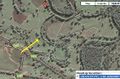
Yellow arrow was where I was, google marker where I should have been..

Grinning mug shot...


Achievements