Difference between revisions of "2010-08-13 66 25"
From Geohashing
imported>Isopekka |
imported>Isopekka (→Valokuvia) |
||
| Line 33: | Line 33: | ||
<Gallery> | <Gallery> | ||
| − | Image:| | + | Image:Geohäsläys2 008.JPG| 160 m to the ground zero |
| − | Image: | | + | Image: Geohäsläys2 007.JPG| 130 m to the ground zero |
| − | Image:| | + | Image:Geohäsläys2 006.JPG| 30 m to the ground zero |
| − | Image:| | + | Image:Geohäsläys2 005.JPG| 5 m to the ground zero |
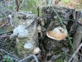
| − | Image:| | + | Image:Geohäsläys2 004.JPG| 3 m to the ground zero |
| + | Image:Geohäsläys2 001.JPG| Ground Zero Point | ||
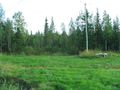
| + | Image:Geohäsläys2 003.JPG| View to the West from zero point | ||
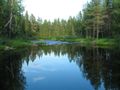
| + | Image:Geohäsläys2 008.JPG| The Ternu river about 180 m from the ground zero | ||
</Gallery> | </Gallery> | ||
Revision as of 17:02, 13 August 2010
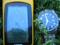
| Fri 13 Aug 2010 in 66,25: 66.4590373, 25.3103065 geohashing.info google osm bing/os kml crox |
Sijainti
Osallistujat
- isopekka ihan yksin suunnittelee käyvänsä
Tutkimusretki
Valokuvia
160 m to the ground zero
130 m to the ground zero
30 m to the ground zero
5 m to the ground zero
3 m to the ground zero
Ground Zero Point
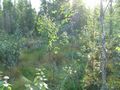
View to the West from zero point
The Ternu river about 180 m from the ground zero


Saavutukset