Difference between revisions of "2010-08-27 37 -88"
From Geohashing
imported>SporkOnABike ([live picture] this is the 'road' we were supposed to tirn on. [http://www.openstreetmap.org/?lat=37.0882158&lon=-88.60212296666667&zoom=16&layers=B000FTF @37.0882,-88.6021]) |
imported>Jiml m (Move info around, Adjust result codes) |
||
| Line 1: | Line 1: | ||
| − | |||
<!-- If you did not specify these parameters in the template, please substitute appropriate values for IMAGE, LAT, LON, and DATE (YYYY-MM-DD format) | <!-- If you did not specify these parameters in the template, please substitute appropriate values for IMAGE, LAT, LON, and DATE (YYYY-MM-DD format) | ||
| Line 19: | Line 18: | ||
== Location == | == Location == | ||
<!-- where you've surveyed the hash to be --> | <!-- where you've surveyed the hash to be --> | ||
| + | Near West Paducah | ||
== Participants == | == Participants == | ||
<!-- who attended --> | <!-- who attended --> | ||
| + | * [[User:SporkOnABike]] | ||
== Plans == | == Plans == | ||
<!-- what were the original plans --> | <!-- what were the original plans --> | ||
| + | Unknown | ||
== Expedition == | == Expedition == | ||
<!-- how it all turned out. your narrative goes here. --> | <!-- how it all turned out. your narrative goes here. --> | ||
| + | Not sure. Doesn't look like they made it, though. | ||
== Tracklog == | == Tracklog == | ||
| Line 38: | Line 41: | ||
<gallery perrow="5"> | <gallery perrow="5"> | ||
| − | Image:2010-08-27_37_-88_22-30-14-014.jpg | | + | Image:2010-08-27_37_-88_22-30-14-014.jpg | Not terrain suitable for flip-flops. [http://www.openstreetmap.org/?lat=37.0882158&lon=-88.60212296666667&zoom=16&layers=B000FTF @37.0882,-88.6021] |
| − | Image:2010-08-27_37_-88_22-31-12-693.jpg | | + | Image:2010-08-27_37_-88_22-31-12-693.jpg | This is the 'road' we were supposed to turn on. [http://www.openstreetmap.org/?lat=37.0882158&lon=-88.60212296666667&zoom=16&layers=B000FTF @37.0882,-88.6021] |
</gallery> | </gallery> | ||
| Line 52: | Line 55: | ||
[[Category:New report]] | [[Category:New report]] | ||
| − | |||
| − | |||
| − | |||
| − | |||
| − | |||
[[Category:Expeditions]] | [[Category:Expeditions]] | ||
| − | + | ||
[[Category:Expeditions with photos]] | [[Category:Expeditions with photos]] | ||
| − | |||
| − | |||
| − | |||
<!-- if you reached your coords: | <!-- if you reached your coords: | ||
Revision as of 00:49, 29 August 2010
| Fri 27 Aug 2010 in 37,-88: 37.1153495, -88.7117253 geohashing.info google osm bing/os kml crox |
Location
Near West Paducah
Participants
Plans
Unknown
Expedition
Not sure. Doesn't look like they made it, though.
Tracklog
Photos
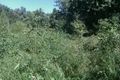
Not terrain suitable for flip-flops. @37.0882,-88.6021
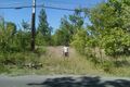
This is the 'road' we were supposed to turn on. @37.0882,-88.6021


Achievements