Difference between revisions of "2010-09-11 46 -120"
From Geohashing
imported>AeroIllini |
imported>AeroIllini |
||
| Line 1: | Line 1: | ||
__NOTOC__ | __NOTOC__ | ||
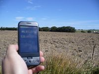
| + | [[File:AeroIllini 2010-09-11_47_-120.jpg|200px|thumb|right|Photo within 300ft of the point.]] | ||
===Participants=== | ===Participants=== | ||
[[User:AeroIllini|AeroIllini]] and friend | [[User:AeroIllini|AeroIllini]] and friend | ||
| Line 8: | Line 9: | ||
===Expedition=== | ===Expedition=== | ||
| − | The point itself was not reached, since it was on private property, but a photo was taken of the point from the road. | + | The point itself was not reached, since it was on private property, but a photo was taken of the point from the road, about 300 feet distant. |
===Result=== | ===Result=== | ||
Success! | Success! | ||
Revision as of 05:08, 14 September 2010
Participants
AeroIllini and friend
Location
The spot was located in a private field one exit south of Ellensburg on I-82.
Expedition
The point itself was not reached, since it was on private property, but a photo was taken of the point from the road, about 300 feet distant.
Result
Success!
