Difference between revisions of "2010-01-01 31 -110"
From Geohashing
imported>Jiml m (Adjust Result codes) |
imported>FippeBot m (Location) |
||
| Line 25: | Line 25: | ||
[[Category:Coordinates not reached]] | [[Category:Coordinates not reached]] | ||
[[Category:Not reached - Time constraints]] | [[Category:Not reached - Time constraints]] | ||
| + | {{location|US|AZ|SA}} | ||
Latest revision as of 00:20, 9 August 2019
| Fri 1 Jan 2010 in Nogales: 31.6609511, -110.8701277 geohashing.info google osm bing/os kml crox |
Contents
Location
Forest Service Road, south of Santa Rita Mountains
Participants
Expedition
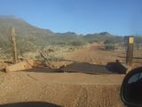
Late start and lots of driving on a Forest Service Road. Slow going to the point we were running out of daylight. Obstacles included the broken cattle guard, which we conquered. With VERY little chance of reaching the hash point in time (and Wyle's reluctance to 4WD out in the dark and be late for family dinner), we aborted the attempt and opted for a stroll on a nearby nature trail. Definitely a candidate for a return trip in the future.
