Difference between revisions of "2011-01-20 53 10"
From Geohashing
imported>Mtu (Created page with "{{meetup graticule | lat=53 | lon=10 | date=2011-01-20 }} __NOTOC__ == Location == In a small forest next to a residential area in north-western Hamburg, easily reachable by th...") |
imported>Mtu |
||
| Line 1: | Line 1: | ||
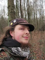
| + | [[Image:{{{image|2011-01-20-53-10 grin.jpg}}}|180px|thumb|left|Looking closely, you can see that I am cold but proud!]] | ||
{{meetup graticule | {{meetup graticule | ||
| lat=53 | | lat=53 | ||
| Line 14: | Line 15: | ||
==Planning== | ==Planning== | ||
I will probably be there early in the day. | I will probably be there early in the day. | ||
| + | |||
| + | ==Expedition== | ||
| + | w00t! I cycled the whole way and back, which I think is pretty amazing, what with being a lazy, fat nerd and all. The trip was very uneventful, though, so I'll just present my proof and photos and collect my achievements :) | ||
| + | |||
| + | ==Tracklog== | ||
| + | Due to technical problems, only my way back is properly and completely recorded and displayed [http://www.everytrail.com/view_trip.php?trip_id=940426 on EveryTrail]. But since I took the exact same way back as when I got to the hash, there's no significant loss of data. | ||
| + | |||
| + | ==Photos== | ||
| + | <gallery perrow="4"> | ||
| + | File:2011-01-20-53-10 bike.jpg|My trusted vehicle enjoying a short rest. | ||
| + | File:2011-01-20-53-10 proof.jpg|Check out how I got the fricken numnbers ''just right!'' | ||
| + | File:2011-01-20-53-10 marker.jpg|Kudos to [http://activegeohasher.com/geohash/2011-01-20/53/10 Active geohasher]! | ||
| + | File:2011-01-20-53-10 grin.jpg|Stupid Grin™ | ||
| + | </gallery> | ||
Revision as of 15:52, 20 January 2011
| Thu 20 Jan 2011 in 53,10: 53.6393546, 10.1442704 geohashing.info google osm bing/os kml crox |
Location
In a small forest next to a residential area in north-western Hamburg, easily reachable by the U1 subway line.
Participants
Planning
I will probably be there early in the day.
Expedition
w00t! I cycled the whole way and back, which I think is pretty amazing, what with being a lazy, fat nerd and all. The trip was very uneventful, though, so I'll just present my proof and photos and collect my achievements :)
Tracklog
Due to technical problems, only my way back is properly and completely recorded and displayed on EveryTrail. But since I took the exact same way back as when I got to the hash, there's no significant loss of data.
Photos
Kudos to Active geohasher!


