Difference between revisions of "2011-08-26 49 10"
From Geohashing
imported>Gefrierbrand |
imported>Gefrierbrand |
||
| Line 7: | Line 7: | ||
== Location == | == Location == | ||
| − | In the middle of a corn field | + | In the middle of a corn field near Dipbach. |
== Participants == | == Participants == | ||
| Line 19: | Line 19: | ||
== Gallery == | == Gallery == | ||
| − | <gallery> | + | <gallery>File:2011-08-26 49 10 Planning.JPG |
| + | I started planning my tour using a bicycle map where I marked the locations as close as I could | ||
| + | |||
| + | File:2011-08-26 49 10 start.JPG | ||
| + | Start point in front of our house. Yes I wore that T-Shirt intentionally. | ||
| + | |||
| + | File:2011-08-26 49 10 view.JPG | ||
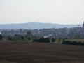
| + | Beautiful view over Estenfeld and Würzburg in the background. | ||
| + | |||
| + | File:2011-08-26 49 10 view zoom.JPG | ||
| + | Again view over Estenfeld and Würzburg, but pretty zoomed in. You can make out Fortress Marienberg. | ||
| + | |||
| + | File:2011-08-26 49 10 .farmingexhibition.JPG | ||
| + | I came across an Exhibition where quite many people looked at tractors and combine harvesters. | ||
| + | |||
| + | File:2011-08-26 49 10 prosselsheiminsicht.jpg | ||
| + | Bavarian blue sky. The barely visible building with the arrow (old silo) was another station onwards to the Geohash. | ||
| + | |||
| + | File:2011-08-26 49 10 prosselsheim close.JPG | ||
| + | The old silo up front. | ||
| + | |||
| + | File:2011-08-26 49 10 redapple.JPG | ||
| + | One single completely red apple in an otherwise fruit free tree. | ||
| + | |||
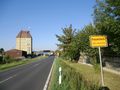
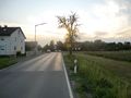
| + | File:2011-08-26 49 10 dipbach.JPG | ||
| + | Entry to Dipbach, the village closest to the Geohash . | ||
| + | |||
| + | File:2011-08-26 49 10 almostthere.JPG | ||
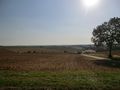
| + | Almost there - The point is somewhere on the left in the corn field. | ||
| + | |||
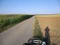
| + | File:2011-08-26 49 10 close.JPG | ||
| + | That's how close I got without using a GPS and navigating only with my Map. | ||
| + | |||
| + | File:2011-08-26 49 10 mapend.JPG | ||
| + | So I had to go in there to reach the point. | ||
| + | |||
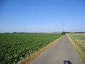
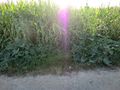
| + | File:2011-08-26 49 10 field.JPG | ||
| + | The first few steps were easy... | ||
| + | |||
| + | File:2011-08-26 49 10 thickest.jpg | ||
| + | ... but it became quite hard to move through the crops without damaging them. | ||
| + | |||
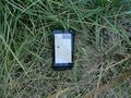
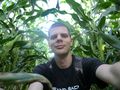
| + | File:2011-08-26 49 10 goal.JPG | ||
| + | Target reached (to the best possible result as the GPS signal was quite weak.) | ||
| + | |||
File:2011-08-26_49_10_xkcd.JPG | File:2011-08-26_49_10_xkcd.JPG | ||
XKCD carved into the soil, little hard to read though | XKCD carved into the soil, little hard to read though | ||
| + | |||
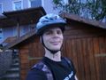
| + | File:2011-08-26 49 10 sillygrin.JPG | ||
| + | Silly grin at the hash location | ||
| + | |||
| + | File:2011-08-26 49 10 wayback.JPG | ||
| + | On my way back some bigger clods showed up. | ||
| + | |||
| + | File:2011-08-26 49 10 homeagain.JPG | ||
| + | Home again. Just in time before the rain started. | ||
| + | |||
</gallery> | </gallery> | ||
more to come | more to come | ||
Revision as of 21:35, 26 August 2011
| Fri 26 Aug 2011 in 49,10: 49.9035423, 10.1313293 geohashing.info google osm bing/os kml crox |
Location
In the middle of a corn field near Dipbach.
Participants
Plans
Still to come
Expedition
Still to come
Gallery
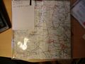
- I started planning my tour using a bicycle map where I marked the locations as close as I could
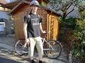
- Start point in front of our house. Yes I wore that T-Shirt intentionally.
- Beautiful view over Estenfeld and Würzburg in the background.
- Again view over Estenfeld and Würzburg, but pretty zoomed in. You can make out Fortress Marienberg.
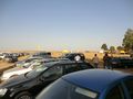
- I came across an Exhibition where quite many people looked at tractors and combine harvesters.
- Bavarian blue sky. The barely visible building with the arrow (old silo) was another station onwards to the Geohash.
- The old silo up front.
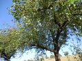
- One single completely red apple in an otherwise fruit free tree.
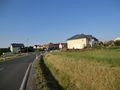
- Entry to Dipbach, the village closest to the Geohash .
- Almost there - The point is somewhere on the left in the corn field.
- That's how close I got without using a GPS and navigating only with my Map.
- So I had to go in there to reach the point.
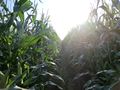
- The first few steps were easy...
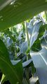
- ... but it became quite hard to move through the crops without damaging them.
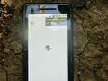
- Target reached (to the best possible result as the GPS signal was quite weak.)
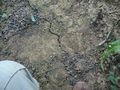
- XKCD carved into the soil, little hard to read though
- Silly grin at the hash location
- On my way back some bigger clods showed up.
- Home again. Just in time before the rain started.


more to come
Achievements
Still to come