Difference between revisions of "2011-11-27 48 -123"
From Geohashing
imported>Wijnland m (→Photos) |
imported>Wijnland (→Tracklog) |
||
| Line 42: | Line 42: | ||
== Tracklog == | == Tracklog == | ||
<!-- if your GPS device keeps a log, you may post a link here --> | <!-- if your GPS device keeps a log, you may post a link here --> | ||
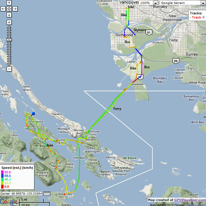
| + | [[File:20111127N48W123_Tracklog.png]] | ||
== Photos == | == Photos == | ||
Revision as of 04:44, 29 November 2011
| Sun 27 Nov 2011 in 48,-123: 48.9273738, -123.5665312 geohashing.info google osm bing/os kml crox |
Location
An island near Vancouver
Participants
Plans
My plan is to visit this location starting from Vancouver:
- Bike to Bridgeport bus exchange
- Bus 620 (with bike) to Twassen ferry
- Ferry Tswassen - Swartzbay
- Ferry Swartzbay - Fulford Harbour
- Bike around Saltspring Island to reach the geohash at the north end
- Ferry LongHarbour - Tswassen
- Bus back to Bridgeport
- Skytrain to get close to my house since I will be tired and to get an extra mode of transportation.
If most things work out, I will not get stuck on this island missing the last ferry...
Expedition
Succes!, more soon.
Tracklog
Photos
Achievements
I should get some achievement for the most elaborate first geohash plan, and for using 5+ different types of transportation.


