Difference between revisions of "2012-02-03 32 -116"
From Geohashing
imported>Scerruti m (→Participants) |
imported>Scerruti ([live picture] Made it [http://www.openstreetmap.org/?lat=32.83844888&lon=-116.70041693&zoom=16&layers=B000FTF @32.8384,-116.7004]) |
||
| Line 39: | Line 39: | ||
--> | --> | ||
<gallery perrow="5"> | <gallery perrow="5"> | ||
| + | |||
| + | Image:2012-02-03_32_-116_19-21-57-174.jpg | Made it [http://www.openstreetmap.org/?lat=32.83844888&lon=-116.70041693&zoom=16&layers=B000FTF @32.8384,-116.7004] | ||
</gallery> | </gallery> | ||
Revision as of 03:22, 4 February 2012
| Fri 3 Feb 2012 in 32,-116: 32.8384373, -116.7004557 geohashing.info google osm bing/os kml crox |
Location
On the south shoulder of Interstate 8, 3/4 of a mile before exit 34, East Willows Rd.

Participants
user:scerruti hopes to get the Redhawk Nation to stop by on the way out to Jewel Valley Ranch.
Plans
Expedition
Tracklog
Photos
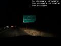
Made it @32.8384,-116.7004

Achievements