Difference between revisions of "2012-02-16 59 18"
From Geohashing
imported>Cjk ([live picture] Why this heavy boom here?) |
imported>Cjk |
||
| Line 1: | Line 1: | ||
| − | + | [[Image:{{{image|2012-02-16_59_18_18-46-18-575.jpg}}}|thumb|left]] | |
| − | |||
| − | |||
| − | [[Image:{{{image| | ||
| − | |||
| − | |||
| − | |||
| − | |||
| − | |||
| − | |||
{{meetup graticule | {{meetup graticule | ||
| lat=59 | | lat=59 | ||
| Line 19: | Line 10: | ||
== Location == | == Location == | ||
<!-- where you've surveyed the hash to be --> | <!-- where you've surveyed the hash to be --> | ||
| + | At the far end of | ||
== Participants == | == Participants == | ||
| Line 39: | Line 31: | ||
--> | --> | ||
<gallery perrow="5"> | <gallery perrow="5"> | ||
| + | |||
| + | Image:2012-02-16_59_18_21-50-52-295.jpg | Why this heavy boom here? | ||
| + | |||
| + | Image:2012-02-16_59_18_18-47-09-278.jpg | Danger! | ||
Image:2012-02-16_59_18_18-45-34-315.jpg | TheDoctor with guns firing in the distance [http://www.openstreetmap.org/?lat=59.13710000&lon=18.19230000&zoom=16&layers=B000FTF @59.1371,18.1923] | Image:2012-02-16_59_18_18-45-34-315.jpg | TheDoctor with guns firing in the distance [http://www.openstreetmap.org/?lat=59.13710000&lon=18.19230000&zoom=16&layers=B000FTF @59.1371,18.1923] | ||
| Line 45: | Line 41: | ||
Image:2012-02-16_59_18_18-46-43-143.jpg | Marker [http://www.openstreetmap.org/?lat=59.13710000&lon=18.19230000&zoom=16&layers=B000FTF @59.1371,18.1923] | Image:2012-02-16_59_18_18-46-43-143.jpg | Marker [http://www.openstreetmap.org/?lat=59.13710000&lon=18.19230000&zoom=16&layers=B000FTF @59.1371,18.1923] | ||
| − | |||
| − | |||
Image:2012-02-16_59_18_18-49-20-422.jpg | [http://www.openstreetmap.org/?lat=59.13710000&lon=18.19190000&zoom=16&layers=B000FTF @59.1371,18.1919] | Image:2012-02-16_59_18_18-49-20-422.jpg | [http://www.openstreetmap.org/?lat=59.13710000&lon=18.19190000&zoom=16&layers=B000FTF @59.1371,18.1919] | ||
| − | |||
| − | |||
</gallery> | </gallery> | ||
Revision as of 20:59, 16 February 2012

| Thu 16 Feb 2012 in 59,18: 59.1370548, 18.1922868 geohashing.info google osm bing/os kml crox |
Location
At the far end of
Participants
Plans
Expedition
- We are in the middle of a firing range -- Cjk @59.1371,18.1923 18:43, 16 February 2012 (CET)
Tracklog
Photos
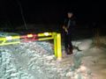
Why this heavy boom here?
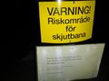
Danger!

TheDoctor with guns firing in the distance @59.1371,18.1923
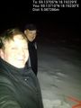
Carl-Johan and TheDoctor @59.1371,18.1923
Marker @59.1371,18.1923


Achievements