Difference between revisions of "2012-03-28 50 8"
From Geohashing
imported>Telegnom (→Location) |
imported>Telegnom (→Tracklog) |
||
| Line 27: | Line 27: | ||
== Tracklog == | == Tracklog == | ||
<!-- if your GPS device keeps a log, you may post a link here --> | <!-- if your GPS device keeps a log, you may post a link here --> | ||
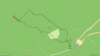
| + | telegnom's tracklog: <br /> | ||
| + | [[File:2012 03 28-track-telegnom.png|350px|telegnom's track]] | ||
== Photos == | == Photos == | ||
Revision as of 16:53, 28 March 2012
| Wed 28 Mar 2012 in 50,8: 50.2292002, 8.4668425 geohashing.info google osm bing/os kml crox |
Location
Somewhere in the woods on the hillside of the "Großer Feldberg" which is the highest mountain in the hills of the Taunus.
Participants
Plans
Draradech, Telegnom trying to be there around 17:00 maybe meeting LadyBB, M?
Expedition
Tracklog
Photos
Achievements
