Difference between revisions of "2012-04-05 -35 149"
From Geohashing
imported>1PE (Created page with "{{ subst:Expedition |lat = -35|lon = 149 |date = 2012-04-05 }}") |
imported>1PE |
||
| Line 1: | Line 1: | ||
| − | |||
<!-- If you did not specify these parameters in the template, please substitute appropriate values for IMAGE, LAT, LON, and DATE (YYYY-MM-DD format) | <!-- If you did not specify these parameters in the template, please substitute appropriate values for IMAGE, LAT, LON, and DATE (YYYY-MM-DD format) | ||
| − | |||
| − | |||
Remove this section if you don't want an image at the top (left) of your report. You should remove the "Image:" or "File:" | Remove this section if you don't want an image at the top (left) of your report. You should remove the "Image:" or "File:" | ||
| Line 9: | Line 6: | ||
And DON'T FORGET to add your expedition and the best photo you took to the gallery on the Main Page! We'd love to read your report, but that means we first have to discover it! | And DON'T FORGET to add your expedition and the best photo you took to the gallery on the Main Page! We'd love to read your report, but that means we first have to discover it! | ||
--> | --> | ||
| + | [[Image:{{{image|2012-04-05 -35 149A.JPG}}}|thumb|left]] | ||
{{meetup graticule | {{meetup graticule | ||
| lat=-35 | | lat=-35 | ||
| Line 18: | Line 16: | ||
__NOTOC__ | __NOTOC__ | ||
== Location == | == Location == | ||
| − | + | Along a fence line south of the Queanbeyan Quarry, off Old Cooma Road. | |
== Participants == | == Participants == | ||
| − | + | [[User:1PE|1PE]] | |
== Plans == | == Plans == | ||
| − | + | Get there after a meeting in Queanbeyan during the afternoon. | |
== Expedition == | == Expedition == | ||
| − | + | ===1PE=== | |
| + | The address on the roadside mail boxes bore no relationship to the supposed address. I navigated by road turns and landmarks. The gravel track had recently been re-graded and there were sharp stones, so I drove carefully on my 'road' tyres. At the expcted kink in the road I was able to stop beside a substantial gate with the fence disappearing at right angles. There were regular signs saying QUARRY SITE KEEP OUT. So, I went no further, fixed the ActiveGeohasher poster beside the gate, took my pictures, and left. | ||
== Tracklog == | == Tracklog == | ||
| Line 34: | Line 33: | ||
== Photos == | == Photos == | ||
<!-- Insert pictures between the gallery tags using the following format: | <!-- Insert pictures between the gallery tags using the following format: | ||
| − | |||
--> | --> | ||
<gallery perrow="5"> | <gallery perrow="5"> | ||
| + | Image:2012-04-05_-35_149A.JPG | I am not a quarryman. | ||
| + | Image:2012-04-05_-35_149B.JPG | So, I kept out. | ||
</gallery> | </gallery> | ||
| Line 52: | Line 52: | ||
[[Category:Expedition planning]] | [[Category:Expedition planning]] | ||
--> | --> | ||
| + | |||
| + | [[Category:Expeditions]] | ||
| + | [[Category:Expeditions with photos]] | ||
| + | [[Category:Coordinates not reached]] | ||
| + | [[Category:Not reached - No public access]] | ||
| + | [[Category:Expedition without GPS]] | ||
<!-- An actual expedition: | <!-- An actual expedition: | ||
| − | + | ||
-- and one or more of -- | -- and one or more of -- | ||
| − | + | ||
[[Category:Expeditions with videos]] | [[Category:Expeditions with videos]] | ||
| − | + | ||
--> | --> | ||
| Line 66: | Line 72: | ||
<!-- or if you failed :( | <!-- or if you failed :( | ||
| − | + | ||
-- and a reason -- | -- and a reason -- | ||
[[Category:Not reached - Mother Nature]] when there is a natural obstacle between you and the target | [[Category:Not reached - Mother Nature]] when there is a natural obstacle between you and the target | ||
Revision as of 07:57, 5 April 2012

| Thu 5 Apr 2012 in -35,149: -35.4048311, 149.2127302 geohashing.info google osm bing/os kml crox |
Location
Along a fence line south of the Queanbeyan Quarry, off Old Cooma Road.
Participants
Plans
Get there after a meeting in Queanbeyan during the afternoon.
Expedition
1PE
The address on the roadside mail boxes bore no relationship to the supposed address. I navigated by road turns and landmarks. The gravel track had recently been re-graded and there were sharp stones, so I drove carefully on my 'road' tyres. At the expcted kink in the road I was able to stop beside a substantial gate with the fence disappearing at right angles. There were regular signs saying QUARRY SITE KEEP OUT. So, I went no further, fixed the ActiveGeohasher poster beside the gate, took my pictures, and left.
Tracklog
Photos
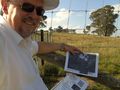
I am not a quarryman.
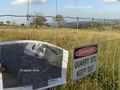
So, I kept out.

Achievements