Difference between revisions of "2012-04-14 42 -71"
From Geohashing
imported>ChrisG (→Plans) |
imported>ChrisG ([live picture] Barrett Park, Leominster, Massachusetts [http://www.openstreetmap.org/?lat=42.52175594&lon=-71.77297305&zoom=16&layers=B000FTF @42.5218,-71.7730]) |
||
| Line 42: | Line 42: | ||
Image:2012-04-14_42_-71_16-11-31-231.jpg | My first hashpoint [http://www.openstreetmap.org/?lat=42.51560731&lon=-71.75626353&zoom=16&layers=B000FTF @42.5156,-71.7563] | Image:2012-04-14_42_-71_16-11-31-231.jpg | My first hashpoint [http://www.openstreetmap.org/?lat=42.51560731&lon=-71.75626353&zoom=16&layers=B000FTF @42.5156,-71.7563] | ||
| + | |||
| + | Image:2012-04-14_42_-71_16-40-10-989.jpg | Barrett Park, Leominster, Massachusetts [http://www.openstreetmap.org/?lat=42.52175594&lon=-71.77297305&zoom=16&layers=B000FTF @42.5218,-71.7730] | ||
</gallery> | </gallery> | ||
Revision as of 20:40, 14 April 2012
| Sat 14 Apr 2012 in 42,-71: 42.5156201, -71.7562399 geohashing.info google osm bing/os kml crox |
Location
Leominster, MA, Boston graticule
Participants
ChrisG and WifeyGirl
Plans
Didn't really have a plan to be here today... I've been stalking easy locations in the Providence graticule, but haven't found one that works on a day when I'm free. Was planning for a non-geohash outing with WifeyGirl, when it turned into a geohash outing.
Expedition
Tracklog
Photos

My first hashpoint @42.5156,-71.7563
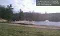
Barrett Park, Leominster, Massachusetts @42.5218,-71.7730


Achievements