Difference between revisions of "2012-06-27 33 -117"
From Geohashing
imported>LucasBrown ([live picture] Geohash Droid map, 35m out [http://www.openstreetmap.org/?lat=33.18675685&lon=-117.07702391&zoom=16&layers=B000FTF @33.1868,-117.0770]) |
imported>LucasBrown |
||
| Line 1: | Line 1: | ||
| − | |||
| − | |||
| − | |||
| − | |||
| − | |||
| − | |||
| − | |||
| − | |||
| − | |||
| − | |||
{{meetup graticule | {{meetup graticule | ||
| lat=33 | | lat=33 | ||
| Line 15: | Line 5: | ||
}} | }} | ||
| − | |||
__NOTOC__ | __NOTOC__ | ||
== Location == | == Location == | ||
| − | + | Near the Deer Park Monastery in Escondido, amid dense brush | |
== Participants == | == Participants == | ||
| − | + | [[User:LucasBrown|LucasBrown]] | |
| − | |||
| − | |||
| − | |||
| − | |||
== Expedition == | == Expedition == | ||
<!-- how it all turned out. your narrative goes here. --> | <!-- how it all turned out. your narrative goes here. --> | ||
| − | + | After several attempts at a northern vehicular approach were thwarted by locked gates more than a kilometer from the hashpoint, a southern approach was attempted by driving up Deer Park Road to the monastery's main parking lot, about 200m from the hashpoint. The hasher then walked up the unpaved fire road to within 35m of the hashpoint but could not progress further due to dense brush. | |
| − | |||
| − | |||
== Photos == | == Photos == | ||
| − | |||
| − | |||
| − | |||
<gallery perrow="5"> | <gallery perrow="5"> | ||
Revision as of 03:19, 28 June 2012
| Wed 27 Jun 2012 in 33,-117: 33.1869405, -117.0767071 geohashing.info google osm bing/os kml crox |
Location
Near the Deer Park Monastery in Escondido, amid dense brush
Participants
Expedition
After several attempts at a northern vehicular approach were thwarted by locked gates more than a kilometer from the hashpoint, a southern approach was attempted by driving up Deer Park Road to the monastery's main parking lot, about 200m from the hashpoint. The hasher then walked up the unpaved fire road to within 35m of the hashpoint but could not progress further due to dense brush.
Photos
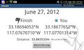
Geohash Droid details page, 35m out @33.1868,-117.0770
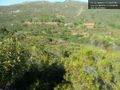
The hashpoint: 35m ahead, in brush too dense to penetrate. The Deer Park Monastery is in the distance. @33.1868,-117.0770
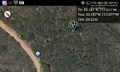
Geohash Droid map, 35m out @33.1868,-117.0770


Achievements