Difference between revisions of "2012-07-21 33 -116"
From Geohashing
imported>LucasBrown (Geohash Droid map at the hashpoint) |
imported>LucasBrown (A critter-hole near the hashpoint. In some places the ground was so dense (porous?) with them that the soil caved in underfoot.) |
||
| Line 44: | Line 44: | ||
Image:2012-07-21_33_-116_18-05-19-015.jpg | Geohash Droid map at the hashpoint | Image:2012-07-21_33_-116_18-05-19-015.jpg | Geohash Droid map at the hashpoint | ||
| + | |||
| + | Image:2012-07-21_33_-116_18-07-01-393.jpg | A critter-hole near the hashpoint. In some places the ground was so dense (porous?) with them that the soil caved in underfoot. | ||
</gallery> | </gallery> | ||
Revision as of 01:07, 22 July 2012
| Sat 21 Jul 2012 in 33,-116: 33.0420860, -116.4041931 geohashing.info google osm bing/os kml crox |
Location
Participants
Plans
Expedition
Tracklog
Photos
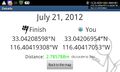
Geohash droid screenshot at the hashpoint @32.9769,-117.0529
Geohash droid screenshot at the hashpoint
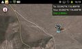
Geohash Droid map at the hashpoint
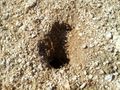
A critter-hole near the hashpoint. In some places the ground was so dense (porous?) with them that the soil caved in underfoot.


Achievements