Difference between revisions of "2012-07-31 -35 149"
imported>1PE |
imported>1PE (pics) |
||
| Line 1: | Line 1: | ||
| − | + | [[Image:{{{image|2012-07-31_-35_149_gate.JPG}}}|thumb|left]] | |
| − | |||
| − | |||
| − | |||
| − | |||
| − | |||
| − | |||
| − | |||
{{meetup graticule | {{meetup graticule | ||
| lat=-35 | | lat=-35 | ||
| Line 42: | Line 35: | ||
--> | --> | ||
<gallery perrow="5"> | <gallery perrow="5"> | ||
| + | file:2012-07-31_-35_149_gate.JPG|Gate to "Private Property" | ||
| + | file:2012-07-31_-35+149_quarry.JPG|Truck heading to the quarry-face. windmills in distance. | ||
</gallery> | </gallery> | ||
| − | |||
== Achievements == | == Achievements == | ||
| Line 54: | Line 48: | ||
| date = 2012-07-31 | | date = 2012-07-31 | ||
| name = [[User:1PE|1PE]] | | name = [[User:1PE|1PE]] | ||
| − | | image = | + | | image = 2012-07-31_-35_149_gate.JPG |
| distance = 5km (the hash is on a farm!) | | distance = 5km (the hash is on a farm!) | ||
}} | }} | ||
Revision as of 13:32, 4 August 2012

| Tue 31 Jul 2012 in -35,149: -35.1736047, 149.4469342 geohashing.info google osm bing/os kml crox |
Location
The hash was on the south-eastern shore of Lake George, north of Bungendore, about 45km from my office in Canberra. It was just north-east of a sand and gravel quarry that gathers materials from the lake edge, and about 1km south of the southern-most windmills of the Lake George Wind Farm.
Participants
Plans
I planned to go on the day, during my lunch time, but a meeting kept me in the office.
Expedition
1PE
The expedition became a two-for-one when the site of the next day's geohash 2012-08-01 -35 149 was only about 0.5km from the previous day's hash. I went on the second day and explored as close as possible to both hashes.
I discovered, as I expected, that the rural property leading to the sites was off-limits, with a sign to that effect.
I took a picture& of the property sign at the entrance, and left the two geohash 'certificates' on the sign.
I then attempted to gain access to the sand/gravel quarry to get a picture from there. I did not want to approach the quarry office as this would require some explanations that I was not willing to give. So, I followed a truck along the quarry access road until I came to the quarry's engineering area, and got another picture& of the truck going to the quarry-face with windmills in the background. The drive back along the access road was without the truck's dust, and much more pleasant.
& My camera decided to not synch with the computer, so I'll put the pictures up when it does.
Photos
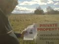
Gate to "Private Property"
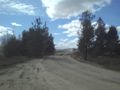
Truck heading to the quarry-face. windmills in distance.

Achievements
1PE earned the No trespassing consolation prize
|