Difference between revisions of "2008-05-24 37 -121"
From Geohashing
imported>Zigdon |
imported>Tapin (→Pictures: Another picture, further away) |
||
| Line 46: | Line 46: | ||
Image:20080524-banner.jpg|Back of a geohasher's car | Image:20080524-banner.jpg|Back of a geohasher's car | ||
Image:20080524-Lookingdown.jpg|Zigdon's closest approach to the spot | Image:20080524-Lookingdown.jpg|Zigdon's closest approach to the spot | ||
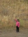
| + | Image:OverThere.jpg|Tapin's (daughter's) closest approach to the spot | ||
</gallery> | </gallery> | ||
Revision as of 02:49, 25 May 2008
| Sat 24 May 2008 in 37,-121: 37.1266480, -121.5475331 geohashing.info google osm bing/os kml crox |

Contents
About
These coordinates were located in the San Jose, California graticule on 2008-05-24, on the shore of Coyote Lake. This was the first Saturday meetup since the project went public.
37.126648°, -121.547534°
People
People who reached these coordinates:
- Joe (and his two kids)
- Dan
- Kate
- Mark
- Jill
- Alex
- Albert
Events
After running into each other, we sat down and had a very nice picnic on the lake edge with beer, wine, cheese and other foodstuffs.
Pictures
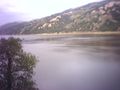
The lake near the spot
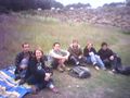
Random picnic
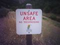
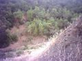
Sketchy terrain
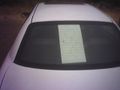
Back of a geohasher's car
Zigdon's closest approach to the spot
Tapin's (daughter's) closest approach to the spot


