Difference between revisions of "2012-09-20 47 -122"
From Geohashing
imported>Thomcat ([live picture] [http://www.openstreetmap.org/?lat=47.83090959&lon=-122.29502968&zoom=16&layers=B000FTF @47.8309,-122.2950]) |
imported>Thomcat ([live picture] Playground structures? No, lets use an artificial rock instead. [http://www.openstreetmap.org/?lat=47.83040730&lon=-122.29501390&zoom=16&layers=B000FTF @47.8304,-122.2950]) |
||
| Line 40: | Line 40: | ||
Image:2012-09-20_47_-122_07-26-26-218.jpg | [http://www.openstreetmap.org/?lat=47.83090959&lon=-122.29502968&zoom=16&layers=B000FTF @47.8309,-122.2950] | Image:2012-09-20_47_-122_07-26-26-218.jpg | [http://www.openstreetmap.org/?lat=47.83090959&lon=-122.29502968&zoom=16&layers=B000FTF @47.8309,-122.2950] | ||
| + | |||
| + | Image:2012-09-20_47_-122_07-29-30-702.jpg | Playground structures? No, lets use an artificial rock instead. [http://www.openstreetmap.org/?lat=47.83040730&lon=-122.29501390&zoom=16&layers=B000FTF @47.8304,-122.2950] | ||
</gallery> | </gallery> | ||
Revision as of 14:29, 20 September 2012
| Thu 20 Sep 2012 in 47,-122: 47.8309051, -122.2950249 geohashing.info google osm bing/os kml crox |
Location
Participants
Plans
Expedition
Tracklog
Photos
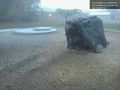
Playground structures? No, lets use an artificial rock instead. @47.8304,-122.2950


Achievements