Difference between revisions of "2012-09-27 33 -117"
From Geohashing
imported>LucasBrown ([live picture] Sign left at the hashpoint [http://www.openstreetmap.org/?lat=33.88200811&lon=-117.95332904&zoom=16&layers=B000FTF @33.8820,-117.9533]) |
imported>LucasBrown ([live picture] The tree with the sign [http://www.openstreetmap.org/?lat=33.88195134&lon=-117.95346596&zoom=16&layers=B000FTF @33.8820,-117.9535]) |
||
| Line 44: | Line 44: | ||
Image:2012-09-27_33_-117_18-43-43-256.jpg | Sign left at the hashpoint [http://www.openstreetmap.org/?lat=33.88200811&lon=-117.95332904&zoom=16&layers=B000FTF @33.8820,-117.9533] | Image:2012-09-27_33_-117_18-43-43-256.jpg | Sign left at the hashpoint [http://www.openstreetmap.org/?lat=33.88200811&lon=-117.95332904&zoom=16&layers=B000FTF @33.8820,-117.9533] | ||
| + | |||
| + | Image:2012-09-27_33_-117_18-45-01-974.jpg | The tree with the sign [http://www.openstreetmap.org/?lat=33.88195134&lon=-117.95346596&zoom=16&layers=B000FTF @33.8820,-117.9535] | ||
</gallery> | </gallery> | ||
Revision as of 01:45, 28 September 2012
| Thu 27 Sep 2012 in 33,-117: 33.8819631, -117.9534117 geohashing.info google osm bing/os kml crox |
Location
Participants
Plans
Expedition
Tracklog
Photos
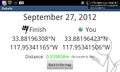
Geohash Droid details page at the hashpoint @33.8820,-117.9534
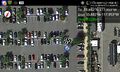
Geohash Droid map at the hashpoint @33.8820,-117.9534
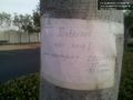
Sign left at the hashpoint @33.8820,-117.9533

The tree with the sign @33.8820,-117.9535


Achievements