Difference between revisions of "2012-09-28 39 -78"
From Geohashing
imported>Ldakota66 (Created page with "<!-- If you did not specify these parameters in the template, please substitute appropriate values for IMAGE, LAT, LON, and DATE (YYYY-MM-DD format) [[Image:{{{image|IMAGE}}}|t...") |
imported>Ldakota66 (→Achievements) |
||
| Line 40: | Line 40: | ||
== Achievements == | == Achievements == | ||
| + | {{No trespassing | ||
| + | | latitude = 39 | ||
| + | | longitude = -78 | ||
| + | | date = 2012-09-28 | ||
| + | | name = Ldakota66 | ||
| + | | image = | ||
| + | | distance = < 0.1 mile | ||
| + | |||
| + | }} | ||
Revision as of 18:34, 1 October 2012
| Fri 28 Sep 2012 in 39,-78: 39.1261583, -78.3304991 geohashing.info google osm bing/os kml crox |
Location
Off Laurel Grove Rd in rural Frederick County, VA.
Participants
Plans
No real plan - I saw the geohash was some what local and decided to go for it.
Expedition
Not much exciting, drove down the road towards the hash. When the GPS advised to turn left I was faced with a gate and a serious looking "Access by permission only" as well as no trespassing sign. I resigned this attempt in favor of not being arrested. ;-)
Tracklog
Photos
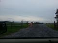
The gate and signs.

Achievements
Ldakota66 earned the No trespassing consolation prize
|