Difference between revisions of "2012-10-15 60 22"
From Geohashing
imported>Suurnesu (Rainy street) |
imported>Suurnesu (→Location) |
||
| Line 19: | Line 19: | ||
== Location == | == Location == | ||
<!-- where you've surveyed the hash to be --> | <!-- where you've surveyed the hash to be --> | ||
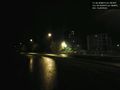
| + | Hashpoint ended up in an easily accesible cycleway some kilometers west from Turku city centre, in Perno suburb. | ||
== Participants == | == Participants == | ||
Revision as of 18:34, 15 October 2012
| Mon 15 Oct 2012 in 60,22: 60.4538044, 22.1561817 geohashing.info google osm bing/os kml crox |
Location
Hashpoint ended up in an easily accesible cycleway some kilometers west from Turku city centre, in Perno suburb.
Participants
Plans
Expedition
- Test -- suurnesu @60.4545,22.1565 13:44, 15 October 2012 (EDT)
Tracklog
Photos

In Perno @60.4539,22.1564
Rainy street


Achievements