Difference between revisions of "2012-10-19 32 -117"
From Geohashing
imported>LucasBrown ([live picture] (LucasBrown) Map at the hashpoint [http://www.openstreetmap.org/?lat=32.96264266&lon=-117.25473757&zoom=16&layers=B000FTF @32.9626,-117.2547]) |
imported>LucasBrown ([live picture] The hashpoint is at thia bush. [http://www.openstreetmap.org/?lat=32.96260000&lon=-117.25500000&zoom=16&layers=B000FTF @32.9626,-117.2550]) |
||
| Line 62: | Line 62: | ||
Image:2012-10-19_32_-117_17-46-18-774.jpg | ([[User:LucasBrown|LucasBrown]]) Map at the hashpoint [http://www.openstreetmap.org/?lat=32.96264266&lon=-117.25473757&zoom=16&layers=B000FTF @32.9626,-117.2547] | Image:2012-10-19_32_-117_17-46-18-774.jpg | ([[User:LucasBrown|LucasBrown]]) Map at the hashpoint [http://www.openstreetmap.org/?lat=32.96264266&lon=-117.25473757&zoom=16&layers=B000FTF @32.9626,-117.2547] | ||
| + | |||
| + | Image:2012-10-19_32_-117_17-46-55-821.jpg | The hashpoint is at thia bush. [http://www.openstreetmap.org/?lat=32.96260000&lon=-117.25500000&zoom=16&layers=B000FTF @32.9626,-117.2550] | ||
</gallery> | </gallery> | ||
Revision as of 00:47, 20 October 2012
| Fri 19 Oct 2012 in 32,-117: 32.9626230, -117.2547169 geohashing.info google osm bing/os kml crox |
Location
Open space (hopefully) near Racetrack View Dr. in Del Mar. - Mathgeek 09:20, 19 October 2012 (PDT)
Participants
- - Mathgeek
- Stephen Cerruti, A', D*
Plans
- - Maybe after work today - Mathgeek 09:27, 19 October 2012 (PDT)
- Head down after school with the boys Stephen Cerruti 14:53, 19 October 2012 (EDT)
Nearby Geocaches
Expedition
- Close as we can get. -- Stephen Cerruti @32.9626,-117.2547 18:23, 19 October 2012 (EDT)
- I made it... I can't believe twice in one week. -- Mathgeek @32.9626,-117.2547 16:33, 19 October 2012 (PDT)
Tracklog
Photos

Stupid grins @32.9625,-117.2548
Nice view today... @32.9626,-117.2547

Obligatory half goofy smile... @32.9626,-117.2547

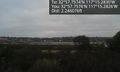
(LucasBrown) Geohash Droid details page at the hashpoint @32.9626,-117.2547
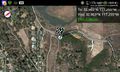
(LucasBrown) Map at the hashpoint @32.9626,-117.2547
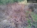
The hashpoint is at thia bush. @32.9626,-117.2550


Achievements