Difference between revisions of "2012-10-26 33 -117"
From Geohashing
imported>LucasBrown ([live picture] Map at the hashpoint [http://www.openstreetmap.org/?lat=33.15897718&lon=-117.26023874&zoom=16&layers=B000FTF @33.1590,-117.2602]) |
imported>LucasBrown ([live picture] The hashpoint is in the middle of this sward. [http://www.openstreetmap.org/?lat=33.15917101&lon=-117.26008858&zoom=16&layers=B000FTF @33.1592,-117.2601]) |
||
| Line 42: | Line 42: | ||
Image:2012-10-26_33_-117_13-16-33-693.jpg | Map at the hashpoint [http://www.openstreetmap.org/?lat=33.15897718&lon=-117.26023874&zoom=16&layers=B000FTF @33.1590,-117.2602] | Image:2012-10-26_33_-117_13-16-33-693.jpg | Map at the hashpoint [http://www.openstreetmap.org/?lat=33.15897718&lon=-117.26023874&zoom=16&layers=B000FTF @33.1590,-117.2602] | ||
| + | |||
| + | Image:2012-10-26_33_-117_13-19-16-433.jpg | The hashpoint is in the middle of this sward. [http://www.openstreetmap.org/?lat=33.15917101&lon=-117.26008858&zoom=16&layers=B000FTF @33.1592,-117.2601] | ||
</gallery> | </gallery> | ||
Revision as of 20:19, 26 October 2012
| Fri 26 Oct 2012 in 33,-117: 33.1589778, -117.2602427 geohashing.info google osm bing/os kml crox |
Location
Participants
Plans
Expedition
Tracklog
Photos
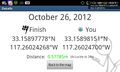
Geohash Droid details page at the hashpoint @33.1590,-117.2602
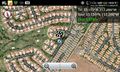
Map at the hashpoint @33.1590,-117.2602

The hashpoint is in the middle of this sward. @33.1592,-117.2601


Achievements