Difference between revisions of "2012-12-23 29 -82"
From Geohashing
imported>Grumpa |
imported>Grumpa (→Photos) |
||
| Line 37: | Line 37: | ||
Image:2012-12-23_29_-82_01.jpg| Georgeous day for flying! | Image:2012-12-23_29_-82_01.jpg| Georgeous day for flying! | ||
Image:2012-12-23_29_-82_02.jpg| Note the contrail going from upper left of picture. You can see its shadow on the ground. I love flying. | Image:2012-12-23_29_-82_02.jpg| Note the contrail going from upper left of picture. You can see its shadow on the ground. I love flying. | ||
| − | Image:2012-12-23_29_-82_03.jpg| Approximate | + | Image:2012-12-23_29_-82_03.jpg| Approximate location of hash point |
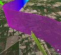
Image:2012-12-23_29_-82_04.jpg| First pass at about 1300'. Yellow is the hash point. Measuring from Google Earth I came within 7' of the point. I amazed myself. | Image:2012-12-23_29_-82_04.jpg| First pass at about 1300'. Yellow is the hash point. Measuring from Google Earth I came within 7' of the point. I amazed myself. | ||
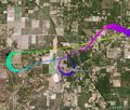
Image:2012-12-23_29_-82_05.jpg| Second pass...about 5400' for the Mile High. Came within 70' this time. Still respectable considering I'm a mile high. | Image:2012-12-23_29_-82_05.jpg| Second pass...about 5400' for the Mile High. Came within 70' this time. Still respectable considering I'm a mile high. | ||
Revision as of 14:39, 24 December 2012
| Sun 23 Dec 2012 in 29,-82: 29.5585921, -82.5100048 geohashing.info google osm bing/os kml crox |
Location
Participants
Plans
Expedition
Tracklog
Photos
Achievements


