Difference between revisions of "2013-03-08 -35 148"
imported>1PE |
imported>1PE (→1PE) |
||
| Line 18: | Line 18: | ||
== Plans == | == Plans == | ||
==[[User:1PE|1PE]]== | ==[[User:1PE|1PE]]== | ||
| − | The hash was on the extreme eastern edge of the graticule, and north, so it was near the suburban fringe of Canberra in the adjoining -35 14'''8''' graticule. I would go by after work, and walk out under the power lines if possible. | + | The hash was on the extreme eastern edge of the graticule, and north, so it was near the suburban fringe of Canberra in the adjoining -35 14'''8''' graticule, [[Tumut, Australia]]. I would go by after work, and walk out under the power lines if possible. |
== Expedition == | == Expedition == | ||
Revision as of 05:39, 8 March 2013
| Fri 8 Mar 2013 in -35,148: -35.2197197, 148.9877614 geohashing.info google osm bing/os kml crox |
Location
Near the 330kV power transmission lines just west of the main Canberra sub-station at Parkwood, and near the "green waste" conversion station.
Participants
Plans
1PE
The hash was on the extreme eastern edge of the graticule, and north, so it was near the suburban fringe of Canberra in the adjoining -35 148 graticule, Tumut, Australia. I would go by after work, and walk out under the power lines if possible.
Expedition
1PE
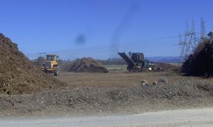
I drove along Parkwood Drive and realised that the grasslands were not navigable, and the herd of cows might make things untenable. Then, I realised that the "green waste" depot extended to very near the line of three power towers. So, I drove in as though I was going to dump some vegetation at the dump face.
I stopped near the fence beside the dump, realising that some no-go signs were there preventing closer access, and took some pictures.
Along the track back out, I got some pics of the green waste recycling equipment.
I stopped near the sub-station and took pictures of the towers, then of the sub-station.


