Difference between revisions of "2013-03-04 48 8"
imported>RecentlyChanged (→Photos) |
imported>RecentlyChanged (→Achievements) |
||
| Line 45: | Line 45: | ||
== Achievements == | == Achievements == | ||
{{#vardefine:ribbonwidth|800px}} | {{#vardefine:ribbonwidth|800px}} | ||
| − | + | {{land geohash | lat = 48 | lon = 8 | date =2013-03-04| name = Kleber, Deuded and RecentlyChanged}} | |
| + | {{Public transport geohash | lat = 48 | lon = 8 | date =2013-03-04| name = Kleber, Deuded and RecentlyChanged | busline = KVV}} | ||
| + | {{Geoflashing | lat = 48 | lon = 8 | date =2013-03-04| name = Kleber}} | ||
| + | <!-- =============== USEFUL CATEGORIES FOLLOW ================ | ||
| − | |||
| − | |||
[[Category:New report]] | [[Category:New report]] | ||
| − | + | [[Category:Expeditions]] | |
| − | |||
| − | [[Category: | ||
| − | |||
| − | |||
| − | |||
| − | |||
[[Category:Expeditions with photos]] | [[Category:Expeditions with photos]] | ||
| − | + | ||
| − | |||
| − | |||
| − | |||
| − | |||
[[Category:Coordinates reached]] | [[Category:Coordinates reached]] | ||
| − | |||
| − | |||
| − | |||
| − | |||
| − | |||
| − | |||
| − | |||
| − | |||
| − | |||
| − | |||
| − | |||
| − | |||
| − | |||
| − | |||
| − | |||
| − | |||
| − | |||
| − | |||
Revision as of 11:14, 10 May 2013
| Mon 4 Mar 2013 in 48,8: 48.9085313, 8.4518289 geohashing.info google osm bing/os kml crox |
Location
In the Forest, near a tram station.
Participants
RecentlyChanged, Deuded and Kleber as I call him know (he's the potential geohasher from 2012-12-13 48 8)
Expedition
We had an exam about higher mathematics, after that we grilled and played a game that is called "flunky-ball". That's about drinking water and applejuice (or this two mixed o.O), really :P After that we lost half of our group because of failing communication. So just the hard core of our group remained. We made our way and it worked without problems. The funnier things you see in the pictures. Kleber lost a bet. But this time I'm really not responsible, because Deuded have all the data, like tracklog and pictures.
Stay tuned RecentlyChanged 18:25, 13 March 2013 (EDT)
Tracklog
Photos
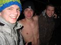
someone lost a bet about how far we are away from the Hash ;)
Good enough (I think)


Achievements
Kleber, Deuded and RecentlyChanged earned the Land geohash achievement
|
Kleber, Deuded and RecentlyChanged earned the Public transport geohash achievement
|
Kleber earned the Geoflashing Achievement
|