Difference between revisions of "2013-03-29 38 -77"
From Geohashing
imported>OfficeLinebacker ([live picture] Allison returns [http://www.openstreetmap.org/?lat=38.45685013&lon=-77.74574478&zoom=16&layers=B000FTF @38.4569,-77.7457]) |
imported>OfficeLinebacker ([live picture] The Steed [http://www.openstreetmap.org/?lat=38.45697245&lon=-77.74569548&zoom=16&layers=B000FTF @38.4570,-77.7457]) |
||
| Line 51: | Line 51: | ||
Image:2013-03-29_38_-77_16-49-03-896.jpg | Allison returns [http://www.openstreetmap.org/?lat=38.45685013&lon=-77.74574478&zoom=16&layers=B000FTF @38.4569,-77.7457] | Image:2013-03-29_38_-77_16-49-03-896.jpg | Allison returns [http://www.openstreetmap.org/?lat=38.45685013&lon=-77.74574478&zoom=16&layers=B000FTF @38.4569,-77.7457] | ||
| + | |||
| + | Image:2013-03-29_38_-77_16-49-22-484.jpg | The Steed [http://www.openstreetmap.org/?lat=38.45697245&lon=-77.74569548&zoom=16&layers=B000FTF @38.4570,-77.7457] | ||
</gallery> | </gallery> | ||
Revision as of 20:49, 29 March 2013
| Fri 29 Mar 2013 in 38,-77: 38.4570218, -77.7479313 geohashing.info google osm bing/os kml crox |
Location
In the Chester F Phelps Wildlife Management Area in Sumerduck, VA
Participants
- OfficeLinebacker (talk)OfficeLinebacker
- Allison
Plans
I am picking up Allison in Annandale at 2:30pm and going to set out from there. Wish us luck!
Expedition
Tracklog
Photos

Made it! @38.4570,-77.7480
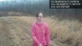
Allison returns @38.4569,-77.7457
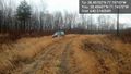
The Steed @38.4570,-77.7457


Achievements