Difference between revisions of "2013-05-22 43 -89"
imported>Swensonj (pictures!) |
imported>Swensonj (→Expedition) |
||
| Line 19: | Line 19: | ||
== Expedition == | == Expedition == | ||
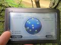
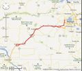
| − | + | I had an errand to run in Madison this afternoon, and the [[43,-89]] hashpoint was extremely conveniently located, right along the highway, on a state trail. I got finished at work around 11:45 a.m. and set out on an expedition. (I forgot to turn off the tracklog when I got to the hash, so the whole trip, errands and all, is shown in the picture above. The hashpoint is where the track bumps north, near the middle.) | |
| + | |||
| + | It was another overcast day, pleasant, but too cool and wet for shorts. I drove through a sprinkling of rain about 10 miles from the hash, but nothing was falling when I got to the parking place. I collected the necessary equipment and walked a short way up the Military Ridge State Trail. As I've mentioned, the GPS is getting touchy, and though I stomped around quite a bit, I couldn't get the proof photo to 5 decimal places of accuracy. It's safe to say, though, that I passed through the hash repeatedly. | ||
| + | |||
| + | Again, no one was around. I took some time to practice my only [[Circus Geohash]] skill, admired the scenery a bit, and then got on with my day. | ||
== Photos == | == Photos == | ||
Revision as of 14:12, 23 May 2013

| Wed 22 May 2013 in 43,-89: 43.0122519, -89.9546343 geohashing.info google osm bing/os kml crox |
Location
Military Ridge State Trail, near Hwy 151 at Pikes Peak Road, west of Barneveld, Wisconsin.
Participants
Plans
I (SwensonJ) hope to hit this around lunchtime. Very accessible, and about as close to my house as you can be in 43,-89!
Expedition
I had an errand to run in Madison this afternoon, and the 43,-89 hashpoint was extremely conveniently located, right along the highway, on a state trail. I got finished at work around 11:45 a.m. and set out on an expedition. (I forgot to turn off the tracklog when I got to the hash, so the whole trip, errands and all, is shown in the picture above. The hashpoint is where the track bumps north, near the middle.)
It was another overcast day, pleasant, but too cool and wet for shorts. I drove through a sprinkling of rain about 10 miles from the hash, but nothing was falling when I got to the parking place. I collected the necessary equipment and walked a short way up the Military Ridge State Trail. As I've mentioned, the GPS is getting touchy, and though I stomped around quite a bit, I couldn't get the proof photo to 5 decimal places of accuracy. It's safe to say, though, that I passed through the hash repeatedly.
Again, no one was around. I took some time to practice my only Circus Geohash skill, admired the scenery a bit, and then got on with my day.
Photos
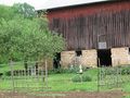
An attractive garden on Pike's Peak Road
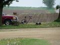
Home-built bicycle lawnmower at the trailhead
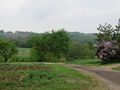
View from the parking place
A day-use pass is required
proof photo of recalcitrant GPS

I was there!
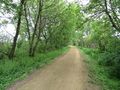
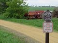
Military Ridge State Trail
XKCD marker

Exhibition of circus-related skill
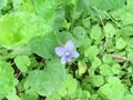
A single violet near the hashpoint

This Geosquishy was found at a gas station up the highway
picture of the tracklog


